CONVECTIVE FORECAST
VALID 06Z FRI 24/10 - 06Z SAT 25/10 2003
ISSUED: 23/10 17:49Z
FORECASTER: GATZEN
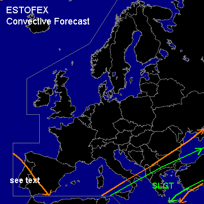
There is a slight risk of severe thunderstorms forecast across Central and eastern Mediterranean
General thunderstorms are forecast across southwestern Iberian Peninsula
SYNOPSIS
Intense and unseasonably expanded long wave trough placed over northern and western Europe, yielding a deep and strong southwesterly flow over the Mediterranean. At the surface ... wavy frontal boundary extending from northen Africa ... to southern Italy ... and further to central Black Sea moves slowly southward. Ahead of this feature ... very warm airmass from the Sahara characterized by steep lapse rates between 900 and 550 hPa as indicated by 12Z LGIR sounding is advected into the eastern Mediterranean (Sirocco).
DISCUSSION
...Eastern and central Mediterranean...
Strong vort-max visible on latest WV satellite image over northern Africa is expected to cross the central Mediterranean tomorrow. 300 hPa wind speed is forecast to reach more than 120 kts over the effected region, and strong synoptic-scale lift is forecast along the frontal boundary, even as WAA should be rather weak referring to BOLAM model output. Additionally, GFS does not indicate large CAPE values within the warm airmass, as the boundary layer should remain rather dry. However ... in the range of the frontal boundary ... moist and convectively mixed airmass and surface dewpoints in the order of 15..20 C are observed... and isolated CAPE values of more than 500 J/kg are expected. Thunderstorms should form at the beginning of the forecast periode and spread ENEward reaching Greece and western Turkey. Strong deep layer shear should support thunderstorm organization, and bow echoes and multicells are expected. Supercells seems to be also likely as enhanced SRH values are forecast. Large hail, severe wind gusts and tornadoes will be possible if supercells may form. However ... flash flooding should be also a significant threat.
...Southwestern Iberian Peninsula...
Upper level trough is expected to cut off west of the Iberian Peninsula, and well mixed airmass over the Biscayan Gulf spreads southward reaching the southwestern Iberian Peninsula during the forecast periode. Thunderstorms should form within this airmass during the forecast periode. Low LCLs and relatively low deep layer shear will possibly enhance the potential for waterspouts.
#