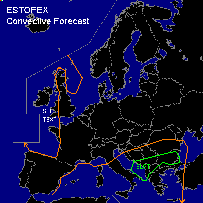
CONVECTIVE FORECAST
VALID 06Z WED 22/10 - 06Z THU 23/10 2003
ISSUED: 21/10 18:58Z
FORECASTER: HAVEN
There is a slight risk of severe thunderstorms forecast across southern Adriatic sea eastward into the Balkan
General thunderstorms are forecast across most of the Mediterranean Sea, Italy and Balkan states
General thunderstorms are forecast across parts of the British Isles, western France and surrounding sea areas
SYNOPSIS
Upper Low over western British Isles is hardly moving, with several cold air troughs rotating around the feature.
The jetstream remains unseasonably south and is west-southwesterly oriented from Iberia over northern Italy towards the southern Ukraina. A few vorticity maxima are embedded in the jetstream and will repeatedly cause large scale upward vertical motion over southeastern Europe.
At lower levels a surface Low, associated with the Upper Low, at 06Z situated near the southwestern tip of Bretagne and remaining almost stationary.
Another low over the western Mediterranean Sea continues slowly east, whilst somewhat deepening, and will cause an increasing south to southwesterly airflow over Italy, the Adriatic Sea and southeastern Europe of moist, warm air. As a result the baroclinic zone from Sardinia over central Adriatic Sea to Romania will move slowly northwards as a warmfront.
DISCUSSION
...southern Adriatic sea eastward into the Balkan...
The advection of warm moist air from the Mediterranean Sea as well as the dynamic upward vertical motion ahead of upper vorticity maxima will rise MLCAPE to values of several hundred J/kg. Storms could develop near the mentioned warmfront, in mountain-areas due to forcing by orography as well as over sea areas where instability will be highest.
Over the largest part of the area vertical windshear will be sufficient to support strong and possibly severe thunderstorms. The best combination of available instability, vertical windhear and large scale upward vertical motion will be in an area from the southern Adriatic Sea eastward into the southern Balkan. It is in this area that a few storms may develop into supercells, especially where low-level winds are favourably modified by orography and topography (i.e. mountains or coastlines). These storms should be capable of producing large hail, damaging winds and possibly a tornado.
...southwestern U.K. and surrounding sea areas...
In the vicinity of the surface low the polar airmass will be well-mixed with at best a few hundred J/kg of MLCAPE available. Many showers are expected to develop, some producing thunder. Deep layer shear will be moderate and the increasing pressure-gradient in the lowest levels around the low will increase the chance for severe windgusts.
Over the southwestern British Isles and surrounding sea areas, winds will also somewhat veer with height, resulting in a 0-3km SRH over 200 m2s-2. So there is a small chance for storms to rotate and a brief mini-supercell cannot be ruled out in that particular area.
The low instability and the fact that the main bulk of gusts will not be related to deep moist convection as well as the low probability of rotating storms will keep all-over threat too low for the issuance of a slight risk and at the moment a SEE TEXT seems appropriate.
#