CONVECTIVE FORECAST
VALID 06Z TUE 21/10 - 06Z WED 22/10 2003
ISSUED: 20/10 20:35Z
FORECASTER: HAKLANDER
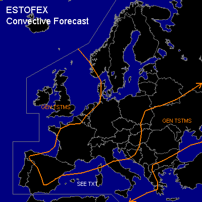
General thunderstorms are forecast across NW Europe, Portugal, S-Spain, Western and Central Mediterranean, large parts of the Balkan and Ukraine.
SYNOPSIS
An elongated upper trough extends from NW Russia across Southern Scandinavia towards the British Isles and cuts off an ULL near the Irish Sea towards the end of the FCST period. In the associated WSWLY flow across Spain, the Western Mediterranean, Italy and the Northern Balkan, a few embedded short waves move ENEWD. Ahead of an embedded VORT MAX which crosses Slovakia and Ukraine, marginal CAPE could yield a few thunderstorms. Special attention goes to a low-level baroclinic wave, which rapidly moves from the Strait of Gibraltar across the Western Mediterranean towards Corsica/Sardinia.
DISCUSSION
...Western Mediterranean...
AFWA MM5 12Z, GFS 12Z and GME12Z runs agree on significant fronto- and cyclogenesis at low levels associated with the aforementioned baroclinic wave. As a result, an impressive SWLY jet streak of possibly 60 knots should form in the course of TUE at 850 hPa, near the Balearic Islands. According to GFS12Z, MUCAPE could attain values of 500-1000 J/kg in the warm sector of the baroclinic wave on TUE evening and into WED night. In combination with the latent instability and the large low-level vertical wind shear, significant WAA is forecast to yield huge 1000-700 hPa SREH values exceeding 500 m²/s². Despite the weak thermodynamic setup, internal storm dynamics due to the environmental kinematics could yield long-lived multicells as well as rightmoving supercells. Current thinking is, that storm activity will mainly be elevated, diminishing the threat of tornadoes. One or two elevated MCS's are not unlikely, given the significant quasi-geostrophic upward forcing over the WAA region. Overall, the most important hazard will likely be severe wind gusts of 50+ knots, due to downward momentum transport in downdrafts. However, MUCAPE seems too low to warrant a SLGT risk ATTM.
...NW Europe...
Weak latent instability near the (sea) surface, owing to cold air at mid and upper levels near the ULL, could result in non-severe thunderstorms during the FCST period. Deep layer shear could exceed 40 knots across the English Channel late TUE and on WED night, which might enhance storm organisation there.
#