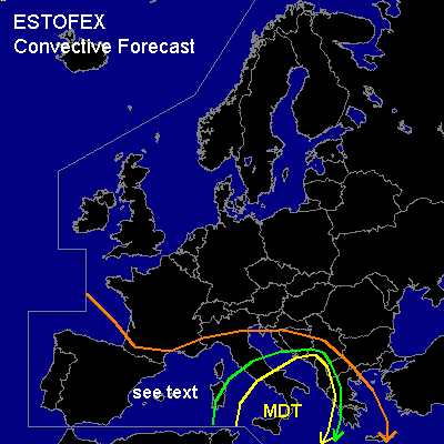

CONVECTIVE FORECAST
VALID 08Z SAT 18/10 - 06Z SUN 19/10 2003
ISSUED: 18/10 08:38Z
FORECASTER: GATZEN
There is a moderate risk of severe thunderstorms forecast across southern and central Mediterranean
There is a slight risk of severe thunderstorms forecast across a region surrounding the MDR risk area
General thunderstorms are forecast across the western Mediterranean, Iberian Peninsula
SYNOPSIS
Dissipating upper ridge over Central Europe ... and relatively strong southern jet over the Mediterranean. Embedded vort-max visible on latest WV satellite image over the western Mediterranean, moving ENE-ward into central Mediterranean. East of this short-wave trough ... advection of warm and unstable airmass into the central Mediterranean takes place. At the surface ... a well defined frontal boundary reaches from southern central Italy to southwestern France ... with a warm front from Italy to Sardinia and an occlusion to the west of it. A cold front moves into the southwestern Mediterranean, reaching Sicily in the evening.
DISCUSSION
...Southern and central Mediterranean...
Plume of unstable airmass characterized by steep lapse rates between 850 and 600 hPa and a relatively moist boundary layer yielding CAPE values in the order of 2000 J/kg as indicated by Tunis 00 UTC- sounding will be the focus of severe convection during the forecast periode. East of mentioned short-wave trough, this airmass is advected into the southern and eastern central Mediterranean. Latest satellite images indicate well organized mesoscale convective systems over southern central Mediterranean. In the next hours ... strong and organized convection should go on over the region. As 0-1 km vertical wind shear is forecast to reach up to 30 kn and high SRH values should be in place over a broad region ... embedded supercells may form ... and large hail, severe wind gusts and tornadoes, some of them may be strong (>F2) are forecast. Additionally, high amounts of rain should be a significant threat over parts of Sicily, Italy and later over the southern Balkans. MCS is expected to cross Italy and the southern Adriatic today and should reach the southern Balkans at the end of the forecast periode. At the southern edge of this MCS ... strong vertical shear and CAPE values of 1500 J/kg or more are forecast, and potential of severe convection should remain during the whole forecast periode.
...Western Mediterranean...
Underneath the trough axis ... convectively mixed airmass is situated. Weak deep layer shear and low CCL are forecast, and the potential for water spouts should be enhanced.
#