CONVECTIVE FORECAST
VALID 06Z TUE 14/10 - 06Z WED 15/10 2003
ISSUED: 13/10 20:45Z
FORECASTER: HAKLANDER
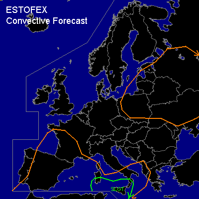
There is a slight risk of severe thunderstorms forecast across Southern Sardinia, parts of the Tyrrhenean Sea, Sicily and the extreme South of Italy.
General thunderstorms are forecast across Spain, the Southwestern half of France, Western en Central parts of the Mediterranean.
General thunderstorms are forecast across Poland, Ukraine, Belarus, the Baltic States and Western Russia.
SYNOPSIS
During the forecast period, a high amplitude ridge over Western Europe intensifies and transforms into a high-over-low block, with a strong upper high present over the North Sea and a weak upper low over the Western Mediterranean. On the WRN and SWRN flank of the associated surface high over Southern Norway, a quasi-stationary frontal zone across the Irish Sea, the English Channel, Northern France and the Alps slowly migrates SWWD. North of this boundary, a significant capping inversion is present due to large scale subsidence in the high. Meanwhile, an extensive ULL across Belarus rotates NEWD. In the WSWLY flow east of the Balearic upper low, a baroclinic wave at low levels is situated north of Algeria at TUE/06Z. The development of this feature is uncertain ATTM. According to Monday's AFWA MM5 12Z run, cyclogenesis should take place over the Balearic Islands during TUE, as a jetstreak of 30-40 kts develops across Northern Algeria, Libia and Sicily at 850 hPa. GFS 12z lets a much shallower low move towards Sardinia during the forecast period. Owing to DCVA, synoptic lifting might result in MCS development near Sicily late TUE, according to this scenario.
DISCUSSION
...SLGT area...
Since we are dealing with a developing situation, observed thermodynamic profiles from MON/12Z seem to be of little use.
We therefore turn to Monday's GFS 12Z run to get an estimate of the amount of CAPE that will be building over the area.
Moderate to high MLCAPE30 values of 1500-2500 J/kg are forecast with little CIN, increasing the likelihood for thunderstorm activity to be widespread.
Deep layer shear of 40-45 knots in combination with considerable amounts of low-level latent instability seems to favor multicells.
In the warm sector of the aforementioned baroclinic feature, SREH values of 150-300 m²/s² are forecast, which might be sufficient for the development of supercells. If these occur, large hail owing to high CAPE and severe wind gusts in downdrafts are possible.
One or two tornadoes cannot be ruled out, since LCL's near the (sea) surface will be low.
...Eastern Europe GEN TSTMS area...
Since the ULL is filled with cold air at mid and upper levels, diurnal heating and upward forcing along lines of low-level convergence are expected to trigger scattered thunderstorms.
#