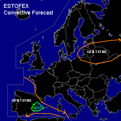

CONVECTIVE FORECAST
VALID 09Z SUN 12/10 - 06Z SUN 12/10 2003
ISSUED: 12/10 09:10Z
FORECASTER: VAN DER VELDE
There is a slight risk of severe thunderstorms forecast across Eastern Spain/Mallorca
General thunderstorms are forecast across Belarus, Western Russia, Baltic states
SYNOPSIS
An elongated high pressure area stretches from Norway into Italy and the Balkan and will not allow convection over a broad area. Positive vorticity areas are east of the Baltic Sea, where a long wave upper air trough filled with cold air and a surface low pressure center are collocated .... and the Iberian Peninsula, where a shallow low surface pressure area and cyclonal upper air pattern reside over the next few days. 8Z Satellite data indicates a frontal structure over northeastern Spain with a pool of moist air following behind it, resembling some circulation. SFLOCs are being reported at 8Z from the Baltic Sea near Lithuania and over southern Spain.
DISCUSSION
...Eastern Spain/Mallorca...
GFS Model indicates CAPE raising up to 1000 J/kg Monday night over the Mediterranean while slight rising motions and model forecast convective precip peak at the Costas of Spain. At 18Z, model forecast 10m wind fields indicate a band of convergence over central Spain. This will probably provide enough triggering for storms to form, while shear will be up to 25 kts 0-6 km, however, cross sections indicate higher speeds around 600 hPa, increasing the amount of shear. Current 00Z soundings indicate plenty of instability above 700 hPa for storms to form, with strong shear and veering winds in the 0-2 km layer, however with stable lower layers there will be not much profit from that. Shear will be higher towards the south but so will LFCs due to the advected dryer desert air, inhibiting storm development.
A slight risk has been issued for the chance of marginally severe hail and marginally severe gusts.
The west coast of Portugal sees favorable conditions for waterspouts in the next 48 hours, as models indicate very unstable lower levels along with a weakly disturbed synoptic pattern.
...Belarus, Western Russia, Baltic states...
Weak thundery activity, with possibly some waterspouts in coastal regions of the Baltic Sea where steep low level lapse rates exist, but also farther inland in areas where pressure gradients are weak, low level instability present and LCLs low.
#