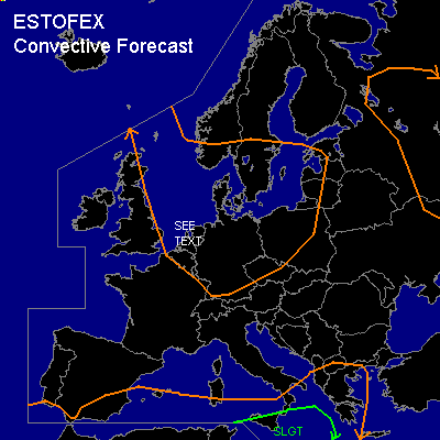

CONVECTIVE FORECAST
VALID 06Z TUE 07/10 - 06Z WED 08/10 2003
ISSUED: 06/10 21:29Z
FORECASTER: HAKLANDER
There is a slight risk of severe thunderstorms forecast across Sicily, parts of the Ionean Sea and the southern Mediterranean.
General thunderstorms are forecast across the North Sea, the Benelux countries, Germany, Denmark, southern Norway and Sweden, the Czech Republic, Poland, the Baltic Sea area.
General thunderstorms are forecast across western parts of Russia.
SYNOPSIS
A strong low over the extreme south of Norway at TUE/06Z, which is present throughout the troposphere, migrates SEWD and reaches northern Poland at WED/06Z. At 300 hPa, a very strong polar jet, with maximum winds exceeding 125 kts at places, runs EWD over Iceland, subsequently SWD across the British Isles before bending eastward again over the Alps towards Ukraine. As the ULL travels SEWD, the entire upper flow pattern shifts accordingly. A zonally oriented, quasistationary baroclinic zone is situated over the southern Mediterranean, with a low-amplitude wave traveling from the Western Mediterranean toward the Ionean Sea.
DISCUSSION
...Sicily, the Southern Mediterranean and the Ionean Sea...
In the warm sector of the aforementioned baroclinic wave, high theta-e air at low levels is advected NEWD across Tunesia and Malta. According to GFS MON/12Z, this process will yield moderate to high MUCAPE values of 2500-3000 J/kg on Wednesday night and early morning.
Associated with the thickness gradient, 0-6 km shear is expected to reach 50-60 kts in the moderate to high CAPE area, increasing the likelihood for organized multicellular storms.
Especially just south of the forecast area conditions appear quite favorable for supercells, as low-level WAA might result in SREH values of 150-250 m²/s². Although vertical wind shear in the lowest km AGL will likely remain < 15 kts, LCL heights will be around 1000 m or lower, which implies a slight risk for supercells to become tornadic. However, large hail and wind gusts exceeding severe limits (50+ kts) seem to be the main threat, due to the lack of significant low-level shear.
...North Sea, the Netherlands and North/Central Germany...
Along the western flank of the ULL, cold air at mid and upper levels / T500 = -30°C / is advected over the relatively warm North Sea, yielding a conditionally stable air mass through a deep layer. Latent instability at low levels will likely suffice for thunderstorm development, as was the case on Monday evening. In combination with marginal amounts of CAPE, strong low level shear is expected over the area as well, with 925 hPa winds / approximately 600 m AGL / possibly reaching 50 kts. Since low level lapse rates will be close to dry-adiabatic, low-end severe wind gusts due to vertical momentum transport in downdrafts will be possible, especially within convective lines that are oriented more or less perpendicular to the low level shear. Although we have considered to issue a SLGT risk for this area, a SEE TEXT seems more appropriate owing to the low CAPE of at most several hundreds of J/kg.
#