CONVECTIVE FORECAST
VALID 06Z MON 06/10 - 06Z TUE 07/10 2003
ISSUED: 05/10 22:28Z
FORECASTER: GROENEMEIJER
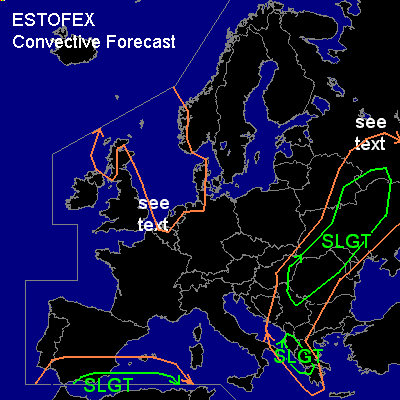
There is a slight risk of severe thunderstorms forecast across the southern Adriatic.
There is a slight risk of severe thunderstorms forecast across the central, northern and northeastern Balkans, the Ukraine, southeastern Belarus and extreme western Russia.
There is a slight risk of severe thunderstorms forecast across southeastern Spain.
General thunderstorms are forecast across The Scottish coasts, the North Sea and its surrounding coastal areas, the extreme southwestern Mediterranean region, the southwestern, central northern and northeastern Balkans, Moldova, parts of the Ukraine, Belarus and western Russia.
SYNOPSIS
Monday at 06Z... a long-wave trough is located along a line from central Scandinavia to the northwestern Balkans. An intense short-wave trough is rounding its base over the northwestern Balkans. This trough will rapidly move eastward during the day, reaching western Russia on Tuesday morning. Upstream... a weak ridge is expected to be located over Germany, followed by a northwesterly mid/upper flow. Another trough is embedded in this flow near Scotland at 06Z and migrates rapidly southeastward reaching a line from northeastern Germany to northern France on Tuesday morning. Further south... a closed upper low is located just west of the Moroccan west coast and moving northeastward reaching southeastern Spain at 06Z on Tuesday morning.
DISCUSSION
...Southern Adriatic...
Ahead of the southeastward-moving trough, an unstable airmass is initially place over the Adriatic as was indicated by the Brindisi LIBR soundings at 12Z and 18Z showing MLCAPE50 around 1200 J/kg. Very strong deep-layer shear... in the 70-95 knot range... will be present over the area. However, at 06Z the unstable air-mass will have been almost depleted, so that the activity will likely diminish during the first hours of the forecast period. Nevertheless, severe gusts, large hail and a small threat of tornadoes will still be present during this time. For more information... ref. day 1 outlook.
...Central, northern and northeastern Balkans, Ukraine, southeastern Belarus, extreme western Russia.
...
A secondy surface cyclone is expected to form ahead of the short-wave trough that moves rapidly northeastward. A narrow band of low latent instability will likely form ahead of the cold front of the developing wave progressing eastward in concert with the upper trough. Over parts of eastern Serbia and Montenegro as well as western Romania... this may cause a band linear convection near the front. Given that low-level and deep-layer shear will be very strong (30-40 kts @ 0-1 km, 70-100 kts @ 0-6km respectively), bowing segments and small vortices may develop and strong wind gusts well in excess of 50 knots may occur as the front passes over these areas during the morning and early afternoon hours. Low LCL levels hint that a few short-lived tornadoes will also be possible. A similar pattern of hazards will be associated with the frontal passage over the Ukraine, Moldova, Belarus and western Russia later on the day.
Downstream of the Carpates mountain range... over southwestern Ukraine and Moldova, a northwesterly advection of relatively high theta-e air is forecast that may result in slightly higher levels of instability of around 500 J/kg MLCAPE50. A few isolated storms may form ahead of the approaching convective line, which are likely to contain rotating updrafts. If they do form, an elevated risk of large hail, wind damage and tornadoes will exist over this area.
During late evening and overnight the latent instability available for frontal convection will likely disappear. However, the background synoptic wind field will likely become very strong behind the cold front and near a forming back-bent occlusion / postfrontal trough. Expect gusts in excess of 50 knots to be possible with any weak post-frontal convection that forms. Possibly... wind gusts will be able to reach severe levels in absence of any deep moist convection.
...southeastern Spain...
Ahead of the upper low approaching the area from the southwest... an increasing area of theta-e advection will be established. Genesis of a warm front near the Spanish south coast seems likely. Numerical models (e.g. GFS0 expect about 1000 J/kg MLCAPE50 to be available south of the front. This will create a favourable setup for a MCS. About 50-80 kt of deep-layer (0-6 km) shear is forecast to form. This implies these storms may well become supercells capable of producing damaging gusts and large hail.
...eastern England and the Benelux countries...
Ahead of the trough moving southeast from Scotland, an occluding cold front will approach the area. A 500 hPa jet streak having its left exit region over the frontal zone during monday morning will help to intensify the front and give it a split front character. GFS cross-sections indicate that a narrow zone of latent instability/CAPE may form ahear of the surface cold front, so that it may be accompanied by a narrow line of free convection. Given that a strong 40-50 low level flow from the southwest is expected to form ahead of the front under a westnorthwesterly mid/upper flow... a somewhat helical inflow may be available to the convective line. It may well be that it develops some bowing segments, that may aid in the production of some nearly severe or severe gusts. Also, short-lived tornadoes are possible with vortices accompanying the line, given that very low LCL's will be present in the frontal zone. However, overall risk of tornado occurrence is limited and this type of tornado normally has a short lifetime and relatively low intensity. Also, most wind gusts will likely be below severe or marginally severe, so that a categorical risk seems not to be warranted at the moment.
#