CONVECTIVE FORECAST
VALID 06Z SUN 05/10 - 06Z MON 06/10 2003
ISSUED: 05/10 11:20Z
FORECASTER: VAN DER VELDE
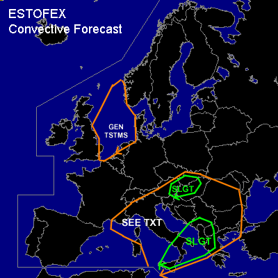
There is a slight risk of severe thunderstorms forecast across Western Balkan, southern Italy
There is a slight risk of severe thunderstorms forecast across East central Europe
General thunderstorms are forecast across North Sea and Mediterranean
SYNOPSIS
Deep upper air trough with axis at 5E at Sun 06Z migrates to 20E on Mon 06Z. A surface low associated with this trough is situated over northern Italy and is forecast to build northeastward. The jet around this upper trough generates strong shear conditions and areas of ascending motion due to vorticity advection/jet streak dynamics. A surface cold front is becoming more defined into the forecast period and will reach the southwestern Balkan around 00Z Monday, a tongue of high theta-e values running ahead of it.
DISCUSSION
...Western Balkan, extreme southern Italy...
Significant instability is present in this area, with 00Z GFS indicating CAPE around 1000 J/kg and 00Z soundings in the area having steep lapse rates. Though there is considerable CIN indicated more southward, rising motions induced by the upper trough will be able to trigger convective activity before and along the cold front.
Atop this unstable airmass, strong shear will be present with >60 kts 0-6 km shear most of the time, and 0-3 km helicities generally 100-200 m2/s2. 50 kts 0-3 km shear will likely be present. Over land areas, 0-1 km shear will exceed 20 kts in many places. Especially the western Balkan elevated coastal regions will have low LCLs. Storms, likely in the form of one or more MCSses that develop may thus pose a threat of tornadoes in embedded supercells, along with damaging winds given the strong winds at low altitude.
Rainfall amounts of a few inches are expected along the Balkan westcoast regions.
...East central Europe...
The surface low deepening and extending northeastwards from northern Italy, in response to the approaching trough/left exit of the jet, will be associated with a few hundred J/kg CAPE according to GFS 00Z. This in combination with strong low-level (>25 kts) and deep layer shear (>50 kts, increasing towards 18Z) will pose a threat of most likely an MCS (due to extreme forcing) with severe gusts and perhaps an embedd supercell with a possible tornado. The likelyhood of storm development seems reasonable given the already going storms within the same low over northern Italy this morning.
...Mediterranean...
GFS may not be adequate in estimating instability within the trough. Any storms developing will encounter strong shear and strong low level winds may cause severe gusts in storms. The 00Z Ajaccio sounding shows very unstable air up to 500 hPa with some 500 J/kg CAPE and very low LCL. With 45-60 kts 0-1 and 0-6km shear and low level veering, this seems to be a potentially tornadic sounding with large hail threat as well.
#