CONVECTIVE FORECAST
VALID 06Z TUE 30/09 - 06Z WED 01/10 2003
ISSUED: 29/09 22:17Z
FORECASTER: HAKLANDER
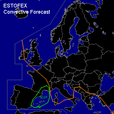
There is a slight risk of severe thunderstorms forecast across eastern Spain, southern France and the western Mediterranean.
General thunderstorms are forecast across the Iberian Peninsula, large parts of France, the western Mediterranean, southern Italy and Sicily, and southeastern Europe.
SYNOPSIS
A longwave SW-NE oriented upper trough, with main axis over the Norwegian Sea and just NW of the British Isles, cuts off an ULL which is forecast W/NW of the Iberian Peninsula (52N13E at 500 hPa) at the end of the forecast period. Across central and eastern parts of the Mediterranean, a slightly meandering westerly jet / 50-80 kts at 300 hPa / is present, while Below the left exit region of the SW-ly jetstreak east of the cut-off ULL, significant low-level cyclogenesis (SLP dropping at least < 995 hPa) is forecast across NW Spain during TUE. The various numerical models do not agree on the movement and intensity of this surface low, but it is generally expected to deepen and move with a northward component. ATTM, the most probable minimum SLP and position at WED/06Z seems to be about 990 hPa near 47N09E. Associated with this low, an area of strong low-level theta-e advection develops over central and eastern Spain, the western Mediterranean, the Bay of Biskay, and France.
DISCUSSION
...Eastern Spain, western Mediterranean, southern France, Bay of Biskay...
On the eastern flank of the aforementioned surface low, a strong SSW-ly low-level jet develops during TUE. Most numeric models calculate 35-40 knot SSW-ly winds at 850 hPa on WED night across the western Mediterranean Sea, eastern Spain, and southern France. At 500 hPa, 60-65 knot WSW-ly winds are calculated over the area, implying high deep shear.
Despite the fact that only 500-1000 J/kg MUCAPE is calculated by GFS (MON/12Z), it is expected that some storms will become severe as dynamics are particularly strong. Owing to the strong low-level wind shear, vertical momentum transport could yield strong convective wind gusts at the surface, which may exceed severe limits (> 50 kts). Linear forcing along the cold front of the developing low could produce bowing segments.
The combination of significant low-level WAA and frontogenesis will result in increasing SREH values during TUE and into WED night, which enhances the probability of storms to become supercellular. In any supercell that forms, large hail and severe wind gusts are to be considered. Since high low-level shear and low LCL's are expected, a tornado should also not be ruled out.
#