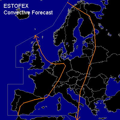
CONVECTIVE FORECAST
VALID 06Z TUE 23/09 - 06Z WED 24/09 2003
ISSUED: 22/09 22:04Z
FORECASTER: HAKLANDER
General thunderstorms are forecast across eastern Spain, the western half of the Mediterranean, Italy, central Europe, the North Sea, Scandinavia and the Baltic States.
SYNOPSIS
At TUE/06Z, a pronounced longwave upper trough, which is preceded by a surface cold front, extends from the Norwegian Sea SWD over southern Norway through the BeNeLux countries. A strong upper high is situated over eastern Romania, with a ridge extending NEWD. West of the upper trough, a ridge extends NWD from the Azores into Iceland. During the forecast period, the upper trough extends southward, intensifies, and sweeps EWD, to end up across the Czech Republic, the Baltic States and northwestern Russia at WED/06Z.
DISCUSSION
...North Sea, Northern Germany, Denmark...
Behind the cold front, colder air at midlevels is advected over the relatively warm North Sea, yielding marginal MUCAPE -- a few hundreds of Jkg -- at places. Meanwhile, several shortwave troughs travel SEWD over the area. Since the air is potentially unstable (theta-e850 exceeds theta-e500), some thunderstorms could be triggered by the shortwave troughs. These storms aren't expected to be severe, since deep layer shear below the upper trough will only be in the order of 20 kts.
...Finland, the Baltic States and Poland...
Solar heating ahead of the cold front will increase latent instability near the surface during the day. Significant DCVA over this area should result in upward vertical motion which could trigger the development of thunderstorms near or along the surface cold front during the day. According to GFS, MUCAPE hardly reaches 100 J/kg ahead of the cold front, which complies well with the MON/12Z rawinsonde observations of Trappes, Uccle, De Bilt and Herstmonceux. Despite moderate to high 0-6 km shear of 50-60 kts over the area, severe weather isn't expected, considering the low CAPE.
...Western Mediterranean...
The MON/12Z sounding of Palma de Mallorca already displayed MLCAPE50 of 1000-1500 J/kg and this latently unstable airmass will still be present over the area tomorrow. Deep layer shear is weak across most of the Mediterranean Sea, but over the western Mediterranean, this shear is slightly increased along a weak north-to-south thickness gradient near the Balearic Islands. According to GFS12Z, the 0-6 km shear could locally reach about 30 kts across this area and this may be sufficient for some more organised thunderstorms, increasing the potential for large hail and severe windgusts. Despite the moderate MLCAPE and the marginal deep layer shear, rotating thunderstorms are unlikely due to SREH values well below 100 m²/s². Owing to weak midlevel flow and precipitable water contents reaching 40 mm across the Balearic Islands, localized flooding might occur with these slowly moving storms.
#