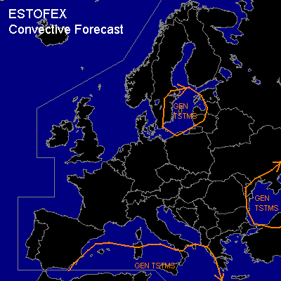

CONVECTIVE FORECAST
VALID 06Z TUE 16/09 - 06Z WED 17/09 2003
ISSUED: 15/09 19:52Z
FORECASTER: HAKLANDER
General thunderstorms are forecast across the western, south-central Mediterranean Sea
General thunderstorms are forecast across the Black Sea area
General thunderstorms are forecast across southern Sweden, the Baltic Sea and the Baltic States
SYNOPSIS
An upper ridge is still present along an axis from the northwestern Iberian Peninsula to Belarus. An upper trough over the Aegean and Ionean Sea connects a cold core ULL over Tunesia with another slightly decaying ULL over the Black Sea. All these systems remain nearly stationary during the forecast period. At 300 hPa, a strong westerly jetstreak over the northeastern Atlantic traverses southern Scandinavia as it becomes northwesterly, and reaches the Baltic Sea at the end of the forecast period.
DISCUSSION
...Western and south-central Mediterranean Sea...
Relatively cold air at mid and upper levels inside the upper trough / about -13°C at 500 hPa over the southern Mediterranean / combined with high theta-e at low levels due to the high SSTs / about 27°C in the southern Mediterranean / yields low to moderate CAPE over the GEN TSTMS area. With significant CIN being absent / see Monday's 12z soundings for Cagliari (S-Sardinia) and Trapani (W-Sicilia) / widespread thunderstorm activity is expected. Atmospheric column precipitable water will likely exceed 35 or even 40 mm at places, which might locally yield high precipitation amounts, considering the weak midlevel winds and the synoptic upward forcing in the vicinity of the Tunesian ULL.
...Black Sea...
The thermodynamic and kinematic setup is somewhat comparable to that of the Mediterranean GEN TSTMS area, with 500 hPa temperatures of -18°C and SSTs around +22°C. However, with low CAPE and much less moisture available to the convection, the risk of flooding seems negligible.
...Baltic Sea...
A slightly unstable polar airmass is advected over the Baltic Sea region. In the course of Tuesday and into Wednesday night, the area will find itself under the left exit region of the aforementioned jetstreak. It is expected that the associated lifting and destabilisation of the tropospheric column will trigger the development of a few thunderstorms.
#