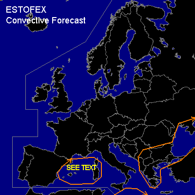

CONVECTIVE FORECAST
VALID 06Z SAT 13/09 - 06Z SUN 14/09 2003
ISSUED: 13/09 02:54Z
FORECASTER: HAVEN
General thunderstorms are forecast across parts of western and south-central Mediterranean Sea, Balcan States and Black Sea
SYNOPSIS
Upper ridge over western Europe is building and extending towards southern Scandinavia, while upper Low over the Balcan is almost stationary. Vorticity maximum over Germany, on Saturday at 06Z will move in a S-SW direction on the downstream side of the upper ridge, and is expected over the western Mediterranean Sea 24 hours later.
Upper trough extending from Albania to Tunesia rotates slowly through the SW-quadrant of the upper Low and will cross Greece later on Saturday, whilst decreasing in activity. Left exit region of a jet over the Aegean Sea points towards the southwestern Black Sea and will shift gradually to the east.
DISCUSSION
...Black Sea, Balcan...
Left exit region over the southwestern Black Sea as well as warm advection over the northwestern Black Sea might support thunderstorms in an environment of marginal to low instability. Shear values are quite low, except for the extreme south and southwest parts of the Black Sea, where a few multicells could form. But severe storms are not expected.
Also a few daily cycle thunderstorms could develop in the vicinity of the upper Low over the Balcan. The combination of low CAPE and low shear will make severe storms unlikely. Only over the southern part of Greece a multicell or two could develop, as this area benefits from better deep layer shear. Windgusts could accompany these storms, but its not likely that they exceed the severe limit of 50 kts.
...Western Mediterranean Sea...
UVM associated with the approaching vorticity maximum will not affect the area before Saturday evening, so any thunderstorm activity will occur later during the period.
The UVM is expected to become moderate/strong, and this will destabilize the atmosphere. Main problem could be the absence of low level moisture, since N to NE-ly surface winds have been advecting a rather dry polar airmass. Nonetheless, a few hundred J/kg of MLCAPE should be available further off shore in the nightime hours to support thunderstorms, as calculated by several models. Since deep layer shear should increase to more than 50 kts, these storms could become severe with a risk of some storms to become supercells producing large hail, damaging winds and perhaps a tornado.
At the moment... the relative small time-window, the low CAPE, as well as the probable lack of low-level moisture makes the all-over threat too low for the issue of a SLIGHT risk.
...South-central Mediterranean Sea...
Marginal unstable conditions (CAPE less than 200 J/kg) together with moderate vertical windshear (30-40 kts) could support a few non-severe multicells near and downstream of the upper trough.
#