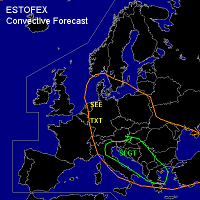

CONVECTIVE FORECAST
VALID 06Z THU 11/09 - 06Z FRI 12/09 2003
ISSUED: 11/09 08:11Z
FORECASTER: DAHL
There is a slight risk of severe thunderstorms forecast across NE Italy, Adriatic, Balkans
General thunderstorms are forecast across west Central Europe
SYNOPSIS
Main feature will be strong jet streak ATTM over the North Sea/BeNeLux/NW Germany ... which is fcst to quickly pivot SSE across central Europe ... and cross the Balkan States during Thursday evening/night. Weak cyclogenesis is accompanying this feature ... with associated cold front/occlusion reaching the north-central Mediterranean regions late Thursday afternoon/evening.
DISCUSSION
...West Central Europe...
In the postfrontal environment over W Germany and BeNeLux ... cellular convection will develop with diurnal heating.
Main problem appears to be the depth of convective mixing within the polar airmass ... GFS and meso-ETA 500 hPa vorticity fields suggest a vort max to cross the S North Sea and NW Germany during the afternoon ... which along with peak heating should enhance depth of convection across the western half of Germany ... deep enough for a TSTMS to form. Shear in the cloud-bearing layer should be on the order of 60 knots ... and potential for a few rotating/splitting updrafts and brief short-line segments exists ... and an isolated marginally severe hail/wind event could occur. With any sustained rotating updraft ... a brief tornado cannot be excluded especially if local augmented SRH due to orography is intercepted. Low coverage of SVR as well as uncertainty with respect to the depth of the convection precludes a SLGT ATTM.
...NE Italy, Adriatic, Balkans
...
As vort max encounters marginally unstable air across the northern Mediterranean ... TSTMS will likely develop over the Balkans ... the Adriatic Sea and Italy ... and possibly move into Greece late in the period. Thermodynamic profiles are very moist with nearly neutral lapse rates ... but deep shear of 50+ knots along with low-level flow perturbations due to the complex terrain could locally create an environment favorable for supercells. These would be capable of producing damaging winds ... large hail and possibly a weak tornado or two given very low LCL/LFC heights. Majority of the storms should be of multicellular nature ... possibly with brief/short line and bowing segments capable of producing marginally severe wind gusts.
#