CONVECTIVE FORECAST
VALID 06Z WED 10/09 - 06Z THU 11/09 2003
ISSUED: 09/09 09:36Z
FORECASTER: HAVEN
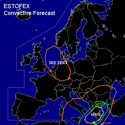
There is a moderate risk of severe thunderstorms forecast across central parts of the Mediterranean Sea, Greece, Aegean Sea
There is a slight risk of severe thunderstorms forecast across the area surrounding the moderate risk, including southwest-Bulgaria
General thunderstorms are forecast across parts of the central Mediterranean Sea, south and central Italy, the Adriatic Sea and Balkan
General thunderstorms are forecast across NorthSea, Benelux, north and central Germany
SYNOPSIS
Upper Low, Wednesday at 06Z over central-Italy continues slowly east and is expected over Bulgaria/south-Romania 24 hours later. Another /smaller/ upper Low over the central NorthSea moves southeast and will reach south-Germany at the end of the forecast period.
At lower levels...surface Low over central Adriatic Sea follows the same track as its associated upper level feature, with minor surface lows on the southern rim. A warmfront from Albania to south-Romania hardly moves north, while the coldfront, almost north-south orientated, over the south-Adriatic Sea moves slowly across far southeast-Europe.
DISCUSSION
...central parts of the Mediterranean Sea, Greece, Aegean Sea...
On the southern periphery of the upper Low, a strong jet /60-70 kts at 500 hPa/ moves from the south-central parts of the Mediterranean towards the southern Aegean Sea. As a result strong UVM is expected to take place in the left-exit region of the jet. This will considerably destabilize the atmosphere and together with the unseasonable high sea surface temperatures, MLCAPE should reach values of between 1500 and 2500 J/kg.
Since deep-layer shear is strong, developing storms will rapidly become severe and organize into supercells for the first few hours of their lifetime. The storms are capable of producing large hail, damaging winds and possibly tornadoes. The strong dynamic forcing, however, will make the development of large clusters very likely. These clusters could grow out into one or two MCSs, with strong-severe gusts and high rainfall-amounts likely. So there is a chance for local floodings in the mountains of Greece and (later) Bulgaria.
...S-Italy and S-Adriatic Sea into the Balkan
...
A decaying MCS might be going in the first hours of the forecast period over south-Italy, the southern Adriatic and coastal areas. Activity could redevelop near the mentioned warmfront, because of warm-advection. However, instability will be low and elevated. Since vertical windshear is also low, no organized severe storms are expected over this area.
...NorthSea, Benelux, north and central Germany ...
Well mixed polar airmass with a few hundred J/kg of CAPE will be available in the vicinity of the upper level Low. Equilibrium levels will be high enough for deep moist convection for showers and thunderstorms. Since deep-layer shear is quite low, these storms will be rather shortlived and organized severe storms can be easily ruled out, although some better storm-organization is possible further from the core. However...with the low windshear and the available moisture, atmospheric conditions are favourable for waterspouts in zones where surface winds converge.
#