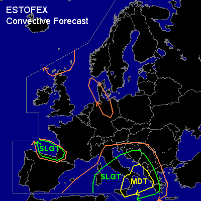

CONVECTIVE FORECAST
VALID 06Z MON 08/09 - 06Z TUE 09/09 2003
ISSUED: 07/09 23:50Z
FORECASTER: GROENEMEIJER
There is a moderate risk of severe thunderstorms forecast across southern Italy, the southern Adriatic, western Croatia, western Serbia and Montenegro, Albania, much of Bosnia, western parts of the F.Y.R. of Macedonia, the Ionean Sea, and parts of western Greece.
There is a slight risk of severe thunderstorms forecast across an area surrounding the moderate risk area including central Italy, Sardinia and the western and western Greece.
There is a slight risk of severe thunderstorms forecast across extreme southwestern France and the Spanish north coast as well as the southern Bay of Biscay.
General thunderstorms are forecast across extreme southwestern France, the Spanish north coast, the southern Bay of Biscay much of the southwestern, and central Mediterranean, the western and southern Balkans, parts of Germany and Denmark and northern Scotland.
SYNOPSIS
A longwave trough is located over western Europe. At 06 Z a shortwave trough will likely be located from the Benelux countries to the Thyrrenean Sea. This shortwave will be followed by a next shortwave entering the Bay of Biscay at the beginning of the period. Downstream... a stationary longwave ridge has an axis from central Finland to Slovakia. Further downstream... a stationary upper low is located over the eastern Ukraine.
DISCUSSION
...south-central Mediterranean...
A plume of warm and very moist air is present over the south-central Mediterranean, south of a diffuse frontal zone from near Algiers to near Brindisi and then southsoutheastward onto the southern Mediterranean. The Trapani sounding of 18Z shows that nearly 3000 J/kg MLCAPE50 is present locally within this air-mass. Eastern parts of the plume are expected to spread further northeastward. Water vapor imagery shows a vigorous shortwave trough over the western Mediterranean that is expected to affect the weather over the area during the forecast period. At the surface a cold front can be analysed near the trough axis, moving into the western Mediterranean basin.
On approach of the trough, deep-layer (0-6km) shear is expected to increase to 40-60 knots. Due to WAA and DCVA ahead of the system, surface cyclogenesis is taking place over the Thyrrenean Sea. As a result low level winds are expected to gradually increase, especially over the moderate risk area where 850 hPa winds are expected to increase to 25-40 knots per 18Z AFWA MM5 model, which will lead to moderate to strong low level (0-1km) shear. The strongest low-level shear will likely be present near the western Balkan and Greek coast, where a strong veering of wind with height will ikely be present as well. This may well provide a quite helical inflow for storms.
Expect scattered storm clusters to be ongoing at the beginning of the period, with the most vigorous storms present just ahead of the cold front, which will likely be located over over the Thyrrenean Sea at the beginning of the forecast period. Other storms will likely be ongoing within the warm plume as they were over the preceding 24 hours. These storms will have an increasing chance of producing severe weather as wind shear and instability increases. The storms will be capable of producing large or very large hail (possibly greater than 5 cm in places) and damaging gusts. Some tornadoes may also occur as LCL heights are low and low-level shear will become rather strong. The highest chance of tornadoes will be with the more isolated storms/supercells forming Monday during daytime ahead of the cold front near and over western Greece and over the southern Adriatic Sea and coasts.
It is likely that many storms will organise into large MCSs. These will have an increasing chance of evolving into severe bow echoes with very strong winds as the background wind field increases during the day. The most intense winds will likely be associated with storms evolving into bow-echoes in the frontal zone that will be over southern Italy during the morning and moving into the southern Adriatic and Ionian Sea during the late morning or early afternoon. The front will reach Albania and Greece will be during late afternoon and early evening.
A major threat of this storm event will be very high precipitation. Amounts of 50-100 mm will likely be measured locally over southern Italy and the western Balkan coast. Amounts of around 100 mm or higher may accumulate over Albania and western Greece. In those areas a high threat of flash flooding will be present and locally mud slides may occur.
...southern Bay of Biscay...
A vort max in the jet streak aloft coupled with a frontal wave at lower levels is forecast to affect the southern Bay of Biscay during the day. Some latent instability on the order of a few 100s of J/kg will likely become available within the warm sector of the developing wave. Ahead adn along the cold front of the wave a few thunderstorms may form. Given the strong low-level background wind field will be strong (35-40 kt winds are forecast @ 850 hPa by GFS 12Z / GFS 18Z) these may well be accompanied by gusts in excess of 50 kt. It is possible that some of the storms will become mini-supercells. If this occurs, large hail and one or two tornadoes will be possible.
#