CONVECTIVE FORECAST
VALID 06Z SUN 07/09 - 06Z MON 08/09 2003
ISSUED: 06/09 21:45Z
FORECASTER: GROENEMEIJER
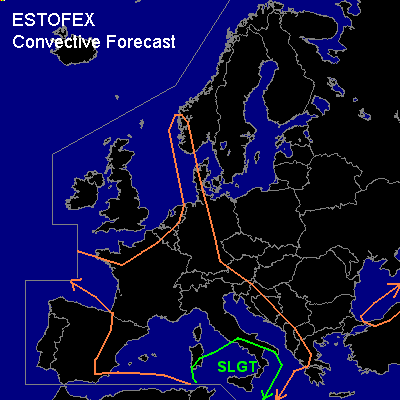
There is a slight risk of severe thunderstorms forecast across the south-central Mediterranean region.
General thunderstorms are forecast across parts of the eastern North Sea, Germany, The Benelux countries, Germany, France, much of th western Mediterranean region, the Adriatic and the western Balkans as well as the southern Black Sea and the Turkish north coast.
SYNOPSIS
A longwave trough is located over western Europe. At 06Z .... an embedded shortwave trough from the British Isles to western France and eastern Spain will progress eastward reaching central a line from the Benelux countries to southern Italy at the end of the forecast period. This shortwave will be followed by a next shortwave located just west of France at the end of the forecast period. Downstream... a stationary longwave ridge has an axis from central Finland to Slovakia. Further downstream... a stationary upper low is located over the eastern Ukraine.
DISCUSSION
...the south-central Mediterranean region....
South of a diffuse frontal zone from east-central Spain to northern Sardinia to southern mainland-Italy,
substantial latent instability / around 1000 - 2000 J/kg / is in place as is shown by the Cagliari LIEE, Trapani LICT and Dar El-Beida DAAG soundings of 18Z, 18Z and 12Z respectiviely. Dew point observations suggest that the moist unstable air-mass has penetrated 100 to 200 km inland into Algeria and Tunisia.
The mid/upper trough is located from western France to eastern Spain at 06Z. Rising motions ahead of this system have given rise to the formation of several thunderstorms over eastern Spain on Sunday evening. Scattered storms will likely keep forming ahead of the upper system as it moves eastward during the forecast period, reaching Italy around 06Z Tuesday morning or somewhat earlier or later depending on the which model is used. These storms may locally be clustered and will have an increasing chance of being severe as increasingly unstable air will be present ahead of the trough while deep-layer (0-6 km) shear is on the order of 30-45 kts so that.rotating updrafts may well form in places. Large hail and severe gusts will be the main threats. GFS suggests that as much as 3500 J/kg MLCAPE30 could be available near Sicily at the end of the forecast period.
The trough is expected to become more intense over time resulting stronger vertical motions. This may lead to one or more extensive MCS's forming early monday morning over southern Italy. Cyclogenesis over central Italy may lead to increased low-level winds over the southern Italian region, increasing the threat of damaging winds. AFWA-MM5 has a very aggressive solution producing 40 knot winds at 850 hPa south of a rapidly deepening cyclone and extremely high preciptiation rates in excess of 50 mm per 3 hours over a large area just after this forecast period. Other models produce significantly less wind and less rain. Current thinking is that events of severe gusts and large hail will be quite scattered and a slight risk will ...at least at this time... suffice. A part of the risk area may need an upgrade tomorrow if models converge toward a more aggressive scenario.
#