CONVECTIVE FORECAST
VALID 06Z THU 04/09 - 06Z FRI 05/09 2003
ISSUED: 03/09 23:26Z
FORECASTER: GROENEMEIJER
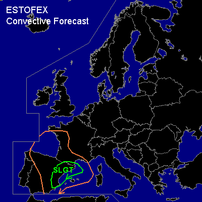
There is a slight risk of severe thunderstorms forecast across northeastern and eastern Spain and parts of extreme southern France
General thunderstorms are forecast across central and eastern Spain, southwestern France, parts of the Bay of Biscay and across the western Mediterranean.
SYNOPSIS
Over eastern Europe a flat upper low is expected to remain stationary with its centre near the border between the northern Ukraine and southeastern Belarus. Upstream... a ridge is located from the British Isles to the Western Alps. This ridge will move slightly eastward during the forecast period. Another upper low is located over the Bay of Biscay. Over Iberia... a southwesterly mid/upper jet is located with a speed max over southeastern Spain.
DISCUSSION
...northeastern and eastern Spain and parts of extreme southern France...
Upward vertical motion is forecast over eastern Spain, mainly in response to warm advection at lower levels as part of the indirect circulation in the jet's exit region. Adiabatic cooling of the rising air and inland advection of low-level moisture in combination with some intermittent sunshine will likely be able to create about 1000-1500 J/kg MLCAPE50 over southeastern and eastern Spain and somewhat lower values inland. Some scattered elevated thunderstorms may have formed over the eastern half of Spain at the beginning of the forcast period, but more storms will likely initiate during the morning and afternoon.
Most of the storms will probably form over eastern and southeastern parts of Spain at first and gradually move over the Mediterranean coastal waters, into northeastern Spain and possibly into extreme southern France as well. The storms inland will only have a small threat of severe weather as only low CAPE will be available there.
As quite strong 45-60kt deep layer (bulk) shear will likely be in place, many storms forming during the day will be supercells. They will likely be capable of producing severe wind gusts and large hail. Because low level shear could be quite strong locally...around 20kts 0-1km shear and LCL heights will likely be relatively low in a broad coastal zone one or two tornadoes will be well possible there.
The storms will have a tendency to become clustered over time, possibly into bowing squall lines that might produce severe gusts. Numerical models hint that a large MCS may develop over northeastern Spain and southern France in the evening and overnight. Large amounts of precipitation may then accumulate.
At this time a slight risk seems to cover the risk given that some uncertainty remains with respect to the amount of CAPE that will be available and uncertainty about the coverage of the storms over east-central and southeastern Spain where CAPE will likely be highest. Howevere, a part of the risk area may be upgraded to moderate risk at a later time if it seems that relatively high CAPE and high storm coverage will occur.
#