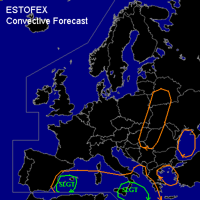

CONVECTIVE FORECAST
VALID 06Z WED 03/09 - 06Z THU 04/09 2003
ISSUED: 02/09 18:10Z
FORECASTER: HAVEN
There is a slight risk of severe thunderstorms forecast across parts of the western Mediterranean Sea including the Baleares
There is a slight risk of severe thunderstorms forecast across parts of the central Mediterranean Sea including Sicily and extreme southern Italy
General thunderstorms are forecast across southwestern and south-central parts of the Mediterranean Sea, the Aegean Sea, the western Black Sea and parts of eastern Europe including the Ukraine.
SYNOPSIS
A meandering upper flow pattern is established over Europe with a ridge over northwestern Europe and a trough located from northwestern Russia via eastern Europe to the central Mediterranean Sea. At lower levels... a polar airmass has invaded much of northern, central and eastern Europe on the eastern flank of a surface high over the British Isles. A tropical airmass is in place over the Mediterranean Sea and adjacent land areas. In general only little changes are expected in this situation.
DISCUSSION
...The southwestern and south-central Mediterranean Sea...
A speed maximum /90 kts at 300 hPa/ near Sicily at 06Z propagates east in the west-east oriented jetstream over the Mediterranean. Enhanced UVM in its left-exit quadrant will become the main focus point for severe thunderstorm development. With the available instability (MLCAPE around 500 J/kg) and deep-layer shear above 50 kts, some storms may develop into supercells, capable of producing large hail, damaging winds and perhaps a tornado. The activity will move east into a more stable environment in the afternoon, resulting in reducing chances for severe weather.
Another speed maximum will enter the southwestern parts of the Mediterranean Sea on Thursday after 00Z. In this area MLCAPE between 500 and 1000 J/kg and a deep layer shear of 40-50 kts is expected. This and the fact that winds will significantly veer with height, makes the southwestern Mediterranean another area where rotating storms are quite well possible later in the period.
...The Ukraine and other parts of eastern Europe...
Ahead of the upper trough, significant UVM will result into areas with stratiform rain, (embedded) showers and possibly a few thunderstorms, especially over the Ukraine where UVM is strongest. To the south... the activity will be more isolated. The present polar airmass will be well-mixed resulting in low CAPE. Together with the low (moderate at best) vertical windshear, the threat will likely remain well below severe limits.
#