CONVECTIVE FORECAST
VALID 06Z FRI 29/08 - 06Z SAT 30/08 2003
ISSUED: 29/08 00:23Z
FORECASTER: GATZEN
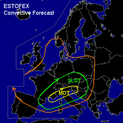
There is a moderate risk of severe thunderstorms forecast across northern Mediterranean
There is a slight risk of severe thunderstorms forecast across Southern Central Europe
There is a slight risk of severe thunderstorms forecast across eastern Central Europe
General thunderstorms are forecast across Central, western and eastern Europe
SYNOPSIS
European flow regime is controlled by an intense long wave trough over Scandinavia. Southwestern European cut off gets involved and will migrate northeastward. At its southern periphery ... very strong jet streak (>100kt @ 300hPa) indicated by water vapor satellite image will move over southern France, northern Italy, and the Alpine region during the forecast periode. At the surface ... low pressure system will cross northern Central Europe. Associated cold front will propagate eastward affecting southern Central Europe and the northern Mediterranean.
DISCUSSION
...Northern Mediterranean...
... MAJOR SEVERE WEATHER OUTBREAK EXPECTED ... Very dangerous weather situation is setting up across the northern Mediterranean. Ahead of propagating southwestern European short wave trough, plume of well mixed airmass originating from the Atlas mountains is advected to the NE. Mid level convection indicates the EML on latest IR satellite image over western Mediterranean. Underneath the cap, rich boundary layer moisture is present, yielding MLCAPE in the order of 2000 J/kg. MCS has formed over southern France ahead of approaching vort max over northern Spain and is expected to move ENE-ward. During the forecast periode ... mentioned plume of mixed airmass should spread ENE-ward affecting the Central Mediterranean. To the north ... soundings indicate a convectively mixed airmass, and thunderstorms have formed over northeastern Italy. It is questionable if the EML can reach northern Italy tomorrow preserving low level moisture and CAPE until the jet streak appears over the region. Otherwise, poorly capped boundary layer could result in widespread convection early in the day, limiting severe potential. However ... airmass should be quite unstable over the northern Mediterranean though, and CAPE should likely reach around 1000 J/kg. As the jet streak appears during the afternoon and early evening hours ... very strong shear profiles are expected over northern Mediterranean, supporting deep organized convection. LEWP will likely form over the northern Mediterranean, and high winds will be the main severe threat. Over northern Italy ... models suggest easterly surface winds and strong low level shear, enhancing the potential for supercells. Large hail and some tornadoes should be possible. However ... it is still possible that the plume of mixed airmass reaches the northern Mediterranean. If this scenario comes true, CAPE should likely reach more than 2000 J/kg, and some long-living supercells and bow echoes should affect the northern Mediterranean. Very large hail, severe wind gusts up to more than 80 kts, and tornadoes, probably strong (F2 or stronger) should be possible. If later observations show that this scenario comes true, an upgrade to HIGH RISK could be necessary.
...Southern Central Europe...
North of approaching jet streak ... convectively mixed airmass is present over southern Central Europe. Thunderstorms have formed over eastern France, the western Alps, and southwestern Germany ATTM. During the forecast periode ... CAPE should likely reach some 100s J/kg within this airmass. Ahead of approaching vort max/ surface cold front ... strong UVM is forecast across southern Central Europe and thunderstorms should go on/ develop over the region. Increasing vertical shear will support organized thunderstorms especially if orography enhances low level helicity. Bow echoes and mesocyclones may form and large hail, damaging wind gusts and brief tornadoes will be possible. North of the Alps ... foehn can likely inhibit convection during the morning hours. If low level moisture will be preserved, severe thunderstorms could form due to strong vertical shear and strong UVM. Large hail and damaging wind gusts should be the main severe threat. Thunderstorms should merge into one or two MCS in the evening hours and spread NEward into Czech Republic and Austria.
...Eastern Central Europe...
In the evening/ night hours ... convective activity /probably MCS/ is forecast to reach eastern Europe. Ahead of the cold front, plume of high THETA-E will be advected into Austria, Hungary, Czech Republic, and Poland. Strong UVM and vertical wind shear will be present, and thunderstorms should go on during the night. Severe winds and isolated large hail should be the main severe threat.
#