
EXTENDED FORECAST
VALID 06Z FRI 29/08 - 06Z SAT 30/08 2003
ISSUED: 27/08 22:55Z
FORECASTER: GROENEMEIJER
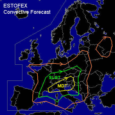
There is a moderate risk of severe thunderstorms forecast across extreme southeastern France, northern Italy, Slovenia, southern Austria and western Croatia.
There is a slight risk of severe thunderstorms forecast across an area surrounding the moderate risk area including much of eastern France southern Germany, The Czech Republic, parts of southern Poland, Slovakia, Austria, Hungary, Croatia, Bosnia-Herzegovina, parts of central Italy and extreme northeastern Spain.
General thunderstorms are forecast across much of central and south-central Europe, extreme southern England, eastern Belarus and a part of western Russia and the extreme northern Ukraine.
SYNOPSIS
An upper low north of Spain will be gradually merging with a larger upper low further north. A strong jet streak embedded withing a westsouthwesterly jet over the western Mediterranean will intensify and propagate eastward. A diffuse cold front will moving into the western mediterranean Basin during the second half of the forecast period. In its left exit region a low-level trough is moving eastward over the northern part of the west Mediterranean BAsin during the day.
DISCUSSION
...northern Italy, Slovenia, Croatia, southern Austria...
Storms will likely be ongoing over northern Italy at the beginning of the forecast period. Storm coverage will likely increase and spread eastward as forcing for upward vertical motion increases. MLCAPE will likely be in the 1500-2500 J/kg range in many places. Deep-layer shear will likely increase to 60-70kt range, while (0-1km) low-level shear will also become quite strong (20-30 kt). Thermodynamic environment seems to be favourable of supercells capable of producing damaging winds, (very) large hail and a few tornadoes, that may be strong (F2 or higher). Uncertainty exist with respect to the effects of convective development early friday morning on the convection later on friday. If large cold pools form early, they may limit the formation of severe storms later. But outflow boundaries may also aid low level mesocyclonic rotation and enhance tornado potential locally. During Friday afternoon the low-level trough will be approaching northern Italy. GFS 27/12Z and AFWA MM5 27/18Z forecast strongly backing low-level flow ahead of the front. This may imply a higher threat of strong tornadoes. Therefore the area will be monitored for a possible upgrade to high risk.
...Hungary, Bosnia-Herzegovina, Slovakia, Poland...
MCSs with a threat of damaging winds and large hail will move into these areas during the evening.
...east-central France, Germany, Switzerland, northern Austria and the Czech Republic....
500 - 1500 J/kg MLCAPE will be present over much of eastern France, Switzerland and southern Germany. Widespread storm activity is expected to be taking place in the area. Given that deep-layer shear is quite strong (40-50 kt), some storms will be severe bow-echoes and supercells capable of producing damaging winds and large hail. Especially near the Jura mountains, in lower Switzerland and southern Germany a stronger flow will be present in the lower troposphere leading to fairly high (20-35 kt) low level shear, creating a small threat of tornadoes and a higher threat of damaging winds. During the day...the convective activity will spread eastward. Supercells and bow-echoes will likely affect southeastern Germany and the Czech Republic and northern Austria during the afternoon and into the evening. There is some uncertainty about the amount of instability and shear that will be present in this area. If conditions will turn out to be very favourable for severe storms an upgrade to moderate risk may be needed for this area.
...southeastern France, extreme northeastern Spain....
Continuing advection of high theta-e low-level air from the Mediterranean will likely be feeding backbuilding MCS's. Strong (50-70kt) deep-layer shear and create a risk of large hail damaging winds. A tornado or two can also not be ruled out, since LCL-heights will likely be low and low-level shear will be rather strong (~20 kts).
#