CONVECTIVE FORECAST
VALID 06Z THU 28/08 - 06Z FRI 29/08 2003
ISSUED: 27/08 12:16Z
FORECASTER: GROENEMEIJER
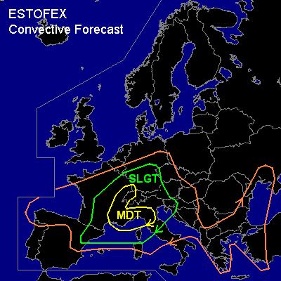
There is a moderate risk of severe thunderstorms forecast across southeastern France, much of Switzerland a part of northwestern Italy and extreme southwestern Germany
There is a slight risk of severe thunderstorms forecast across and area surrounding the MDT RISK area including northeastern Spain, southern, central and eastern France, southern Germany, Switzerland, western Austria, extreme western Czech Republic, northern and central Italy as well as parts of Slovenia and Croatia.
General thunderstorms are forecast across northern and northeastern Spain, much of France, Germany, the Czech Reupblic, the Alps, Italy, the northwestern, western and southern Balkans, the western Black Sea coast and western Turkey.
SYNOPSIS
An upper low is situated over Scandinavia. On its southern flank a strong westerly jet is present. A trough is moving eastward over eastern Europe. The air-mass is rather stable there so that general thunderstorm formation is not anticipated. Another low pressure system is located over the eastern Atlantic, approximately 300 km northwest of Galicia. This system will be slowly moving eastward and will later start to merge with a sharp trough located from the former low pressure area to the the southern British Isles. A westsouthwesterly mid and upper jet streak is expected to form over the western Mediterranean and propagate northeastward during second half of the forecast period.
DISCUSSION
...Northeastern Spain, France, Switzerland, southern Germany...
Over the unseasonably warm western Mediterranean Sea, the boundary layer is recovering from the last thundery episode and becoming increasingly moist as is evident from the various sounding from the area. Tomorrow afternoon the combination of the moist boundary layer capped by as an elevated mixed layer from the Sahara will likely yield MLCAPE on the order of 1500 - 3000 J/kg. An increasing southerly flow ahead of the upper system willenable the unstable air to overspread parts of southeastern France and possibly northeastern Spain as well. Convective intiation is forecast during the late afternoon and evening over Catalunia, southeastern and eastern France and western Switzerland. As deep-layer (0-6 km) shear will be near 40-50 kts, and forcing for upward vertical motion will initially not be strong, scattered supercells seem to be likely. The storms will locally organise into bow echoes. The storms will be capable of producing large hail, that may locally exceed 5 cm diameter and damaging winds. There is also a chance of tornadoes, since LCL heights will be rather low and low-level shear may become rather strong... 0-1 km wind shear could become as large as 20-30 knots. The activity will continue overnight and move into southern Germany as the forcing for upward vertical motion increases further as the left exit region of the jet-streak will overspread the area. It seems likely that the convection will gradually become more and more organised into larger linear convective systems capable of producing damaging winds.
...northern Italy...
Convective initiation is forecast on the southern Alpine flanks during the afternoon and evening. Shear profiles and instability will likely be sufficient for a few severe storms during this time. A higher severe threat over much of northern Italy will likely form during the late evening and into the early night as higher theta-e air will flow over the area and MLCAPE will rise to 1500-3000 J/kg in these areas and the strenghtening mid/upper jet will overspread the area. Deep-layer (0-6 km) shear will likely increase to around 60 knots and low-level shear will locally in the 20-35 range. Supercells and severe bow-echoes capable of producing tornadoes, very large hail (> 5 cm) and very strong winds will likely form. The strongest forcing and highest coverage of storms over Italy seems to be after this forecast period.
#