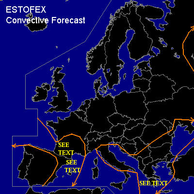

CONVECTIVE FORECAST
VALID 06Z WED 27/08 - 06Z THU 28/08 2003
ISSUED: 26/08 14:34Z
FORECASTER: HAVEN
General thunderstorms are forecast across Albania, Macedonia, Greece, Bosnia, Bulgaria and southeastern Romania.
General thunderstorms are forecast across Southwestern and central France, Eastern Spain, the western Mediterranean Sea and Italy.
SYNOPSIS
A fairly strong cyclonical curved jet-stream located over the Norwegian Basin via North Sea to northern Poland is slowly shifting in a southerly direction as a long wave trough over Scandinavia digs southward. An upper low northwest of Iberia remains nearly stationary, while rather weak westerlies prevail over the central and eastern Mediterranean. An embedded shortwave Wednesday at 06Z over the western Balkans will reach the western Black Sea at the end of the forecast period.
DISCUSSION
...Albania, Macedonia, Greece, Bosnia, Bulgaria and southeastern Romania....
The passing short wave together with surface heating will destabilize the atmosphere with CAPE generally reaching between 600 and 1400 J/kg in the afternoon. Surface convergence near a shallow surface low and locally induced orographic circulations will initiate thunderstorms. These storms are expected to be short-lived single cells and unorganized clusters of storms, since deep layer shear is quite weak. Only in a small zone downstream of the shortwave over extreme southern Greece, wind shear could be high enough to support stronger multicells. Updraft speeds and storm-organization could be strong enough to produce locally marginal large hail or borderline severe wind events. However, the expected coverage is too low for the issuance of a slight risk.
...Southwestern and central France...
An upper ridge of high pressure will shift eastward over central France in the late morning afternoon/early afternoon. Thereafter, a cyclonically curved upper flow will be established over southwestern France on the periphery of the upper low to the west. As a result 0-6km shear will increase to 25-30 kts. Solar heating will increase instability over the area, with CAPE reaching a 600-1200 J/kg in the late afternoon.
Models calculate some large scale upward vertical motion, due to a subtle shortwave in the upper levels. Local surface convergence, due to both hills/mountains and land-sea circulations should initiate deep moist convection in the course of the afternoon.
The vertical wind shear will not be sufficient for well-organized severe storms, although some multicells could locally produce marginal large hail, especially in high-altitude areas where melting-trajects are shorter. Also there is some threat of severe winds because air at 1-2 km AGL is advected from the dry Spanish plains thereby increasing the chance for an evaporatively driven downburst. However, the overall threat seems too low for a slight risk.
...Eastern Spain and western Mediterranean Sea...
Wednesday evening, a jet maximum will curl around the upper low and reach the western Mediterranean Sea on Thursday morning. Strong forcing in the left-exit quadrant of this speed maximum will further enhance instability over the relatively warm waters, were CAPE will reach values of 2000 J/kg or more. This instability and a deep layer shear over 50 kts, will be sufficient for the development of supercells.
Because this scenario is expected on the very end of the outlook-period with a very short time window, no slight risk has been given. However
this area needs to be monitored closely and might need to be upgraded to a slight, possibly moderate risk in Thursdays outlook.
...Bay of Biscay...
Showers and a few thunderstorms will be possible in the vicinity of the upper Low. Increasing pressure-gradient will increase winds at low levels, with windspeeds at 850 hPa locally as high as 45-50 kts. This will support strong to severe windgusts by the strong tubulent mixing. However, these will be mainly not been driven by deep moist convection, so a risk category doesnt seem appropriate.
...The Baltic Sea and its near surroundings...
Cold air aloft (below 25C at 500 hPa) will allow deep convective mixing over relatively warm seawaters. However, activity is expected to be very isolated. A risk category doesnt seem necessary despite the favorable windshear near the jetstream.
#