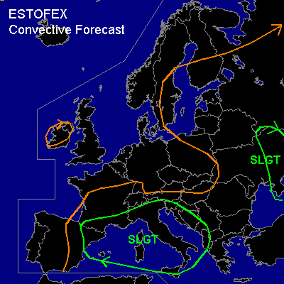

CONVECTIVE FORECAST
VALID 11Z SUN 24/08 - 06Z MON 25/08 2003
ISSUED: 24/08 11:29Z
FORECASTER: GATZEN
There is a slight risk of severe thunderstorms forecast across western Mediterranean
There is a slight risk of severe thunderstorms forecast across southeastern Europe
General thunderstorms are forecast across eastern Mediterranean
General thunderstorms are forecast across parts of eastern Europe
General thunderstorms are forecast across Ireland
SYNOPSIS
Western European omega flow pattern with blocking ridge over the British isles, a western trough over northeastern Atlantic, and a eastern trough over the Baltic states dominates the weather situation over northern and Central Europe. To the south ... weak undulating westerly flow affects the Mediterranean.
DISCUSSION
...Western Mediterranean...
Unusual warm water surface temperature /regional up to more than 30°C/ and mid level well mixed warm airmass originating from the Atlas mountains results in huge low level amount of moisture underneath the capping inversion. Where the boundary layer remains thick, large amount of CAPE are present: 00 UTC sounding over LIRE shows MLCAPE in the order of 2700 J/kg. This should be an example of what we can locally expect today over the western Mediterranean. During the day ... short wave trough migrates eastward across the western Mediterranean, yielding a moderate SW-erly flow /40kn @ 300hPa/ east of it. Synoptic scale UVM should be rather weak, and initiation is expected where orography will give support. Thunderstorms could reach severe level, as CAPE could locally reach more than 1500 J/kg and deep layer shear will be strong enough for organized convection. Large hail, damaging wind gusts and brief tornados should be possible. Best chances for widespread convection should be over northwestern Mediterranean, Italy, the Balkans.
...Southeastern Europe...
Cold front migrates eastward north of the Black Sea. Relatively moist boundary layer and steep lapse rates above results in CAPE values in the order of some 100s J/kg during the day within the warm airmass. Strong upper jetstreak /more than 60kn @ 300hPa/ and strong deep layer shear should support organized convection. Thunderstorms are forecast along the cold front and should quickly merge into one linear MCS. Strong to severe wind gusts should be the main severe threat over the affected region. However ... first isolated cells should possibly rotate due to locally enhanced low level shear and cell interaction with a slight chance for large hail and one or two tornados.
#