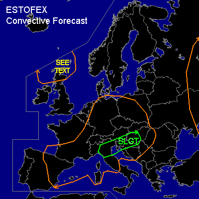

CONVECTIVE FORECAST
VALID 06Z MON 18/08 - 06Z TUE 19/08 2003
ISSUED: 17/08 20:19Z
FORECASTER: HAVEN
There is a slight risk of severe thunderstorms forecast across northern Italy, Slovenia, northern Yugoslavia and western Hungary.
General thunderstorms are forecast across central Europe, the western Iberian Peninsula, southern France, Northern Scotland and parts of western Russia.
SYNOPSIS
An upper low northwest of Scotland moves slowly towards the Norwegian Basin. Associated upper trough Monday at 06Z over central U.K. via central-France to the western-Mediterranean also moves northeast and will arrive at a line from southern Norway to central Germany to Slovenia around midnight. This feature is followed by a shortwave, at 06Z over northwestern Iberia and reaching southern France at 00Z.
At lower levels on monday at 06Z the polar front, separating dry and relatively cool air to its north and moist warm air to its south, is situated over southeast-Poland to northern Germany and slowly lifting northeast as a warmfront. While a minor low over northwestern Germany moves to the western Baltic Sea. A surface trough is extending southeast from this low to eastern Austria at 06Z and expected from central Poland to Hungary at 00Z.
DISCUSSION
...Central Europe...
In the morning hours...several MCS's or large clusters of rainy areas with thunderstorm activity might be ongoing over Germany, the western and central Alps, eastern France and northern Italy. This activity should decrease in the first hours but redevelop/intensify in the afternoon, especially near the surface trough and move east to northeastward.
Instability will become low to moderate with MLCAPE generally between 500 and 1200 J/kg in the late afternoon. Over Slovenia, Hungary and northern Yugoslavia, the airmass will become more unstable with MLCAPE expected between 1200 and 2200 J/kg.
Over large parts of central-Europe deep layer shear of around 30 kts will not be sufficient for organized severe storms, although a few multicells producing marginal large hail or borderline severe winds should be possible with the stronger storms. Largest threat of severe convective weather will be in and around a 200-300 km wide corridor from north-Italy to Slovenia to western-Hungary where deep-layer shear just ahead of the upper trough should reach 35-40 kts, which is marginally sufficient for storm rotation.
If a supercell develops
(very) large hail and windgusts over 50 kts are quite likely. Also a tornado cannot be ruled out. However... strong multicells with locally large hail and damaging winds is expected to become the main convective mode. The relatively dry lowest layers in the southeastern rim of central-Europe could support downdrafts with /theoretically/ any storm that forms. Putting all things together
a slight risk in the mentioned corridor seems the most appropriate choice at the moment.
...Northern Scotland and the surruounding sea areas to the west, north and northeast...
In the polar air on the southern periphery of the upper low...showers are expected that might produce a few rumbles of thunder. The marginal instability will keep the threat of any rotating thunderstorm quite low, despite the 0-6 km shear of around 50 kts.
#