CONVECTIVE FORECAST - UPDATE
VALID 15Z SUN 17/08 - 06Z MON 18/08 2003
ISSUED: 17/08 15:19Z
FORECASTER: GROENEMEIJER
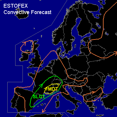
There is a moderate risk of severe thunderstorms forecast across southeastern France, northwestern Italy and southern Switzerland.
There is a slight risk of severe thunderstorms forecast across an area surrounding the moderate risk area including much of southern and eastern France and eastern Spain as well as the western Alpine region and northwestern Italy.
General thunderstorms are forecast across parts of Russia, the Baltic States, Belarus and the extreme northern Ukrain as well as parts of the British Isles, the western mediterranean and much of west-central continental Europe.
SYNOPSIS
A ridge is located from the central Mediterranean to the North Sea. Downstream a closed low is located over northern Russia Scandinavia. Upstream... a trough is located over Iberia that will move northeastward towards central parts of Europe.
DISCUSSION
...France, Italy, western and southern Alps...
High amounts of latent instability (MLCAPE50 around 3000 J/kg...ref 12Z Nimes LFME /Milano LIML soundings) has formed over southern France and the western Po-Valley. In the left exit region of a jet approaching southeastern France a extensive linear MCS has formed. Stronger shear seems to be present than was anticipated earlier on, as 0-6km shear is likely on the order of 40 kts or even higher locally per radiosonde observations and low-level shear may increase during the next few hours as a southerly 35 kt jet might develop over the Provence indicated by AFWA MM5. High CAPE values/ the presence of a well-organised MCS marginally warrants issuing a moderate risk, in particular for the wind threat associated with the system. The strongest wind can be expected where bow-shaped elements form in the line. However, given that low-level shear will be increasing one or two tornadoes may well occur. Another important severe weather threat is that of large hail that may locally be very large (>5 cm) where mesocyclones have formed in the line and near isolated supercells. The MCS will likely affect much of southeastern France during the remainder of the afternoon and evening and will work its way northward towards Switzerland overnight. More isolated storms are currently present ahead of the the MCS. These may merge with the system later on. Also, additional storms may form at the back of the system.
Widespread convective development may occur during the next hours over the western Po-Valley and the southern Alpine slopes of Italy and southern Switzerland where upslope flow is increasing and first deep convection has already initiated per satellite imagery.
Moderately strong shear (around 40 kts 0-6 km deep-layer shear)will also affect this area during the next few hours and convective activity will therefore likely be supercellular in places. A threat of damaging winds, large hail exists over the area. And given that storm coverage may become large over the area a moderate risk is issued for this area as well.
...eastern Spain...
Behind the MCS, isolated thunderstorms have formed over much of eastern and northern Spain, where MLCAPE50 on the order of 1000 J/kg should be available in a somewhat drier air-mass. Especially over eastern parts of Spain deep-layer shear will be sufficient to sustain supercells. A threat of large hail and damagaing wind gusts is likely near these storms.
#