CONVECTIVE FORECAST
VALID 13Z FRI 15/08 - 06Z SAT 16/08 2003
ISSUED: 15/08 13:11Z
FORECASTER: GATZEN
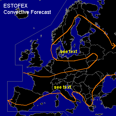
General thunderstorms are forecast across Baltic Sea region
General thunderstorms are forecast across Southern Central Europe
General thunderstorms are forecast across Iberian Peninsula
SYNOPSIS
Intense short-wave trough is situated over the Baltic Sea. Another, relatively weak short wave reaches the Iberian Peninsula during the day. At the surface ... frontal boundary reaches from central France to the northern Alps and further to Czech Republic.
DISCUSSION
...Baltic Sea...
Cold airmass in the range of upper trough destabilizes above the warm water surface of the Baltic Sea. Low level CAPE in the order of some 100s J/kg are forecast. Showers and thunderstorms should go on during the forecast periode. Deep layer wind shear and mesoscale vorticity maxima/ uvm- lines could lead to organized lines of thunderstorms. In association with stronger convection ... isolated strong wind gusts of more than 50 knots will possibly occur due to strong deep layer shear and convectively mixed airmass. Additionally, there is a slight chance for water spouts due to low LCL heights and low level CAPE, especially if orography modifies low level wind shear. Best chances are supposed to be along the lee sides of landmasses.
...Southern Central Europe...
Frontal boundary extending from central France to Austria and Czech Republic, and separates warm airmass over southern Europe from relatively cold airmass to the north. Along this boundary ... showers and thunderstorms have formed and should go on in the day. Weak upper short-wave ridge over western France propagates eastward and convective activity should weaken in the afternoon. In the evening/ night hours ... thunderstorms should affect the northern Balkans. To the south of mentioned frontal boundary ... very moist and warm boundary layer and steep lapse rates above should create high CAPE over southern France, northern Italy, and northern Balkans. If thunderstorms may form ... some of them should become quite strong. Moderate deep layer shear could lead to organized thunderstorms, and isolated supercells are not ruled out attm. Large hail, strong wind gusts and isolated tornadoes will possibly occur. However ... high and mid-level stratiform clouds inhibit strong insolation attm, and a SLGT seems to be not necessary at the moment.
...Iberian Peninsula...
Upper short wave trough reaches the region within the day. Warm air advection east of the trough ... and DCVA should lead to convection. Affected airmass is deeply mixed and strong downdraft winds could develop. High winds of more than 50 knots should be the main severe threat.
#