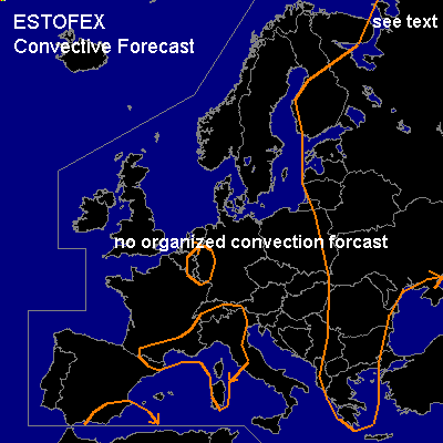

CONVECTIVE FORECAST
VALID 12Z FRI 08/08 - 06Z SAT 09/08 2003
ISSUED: 08/08 12:00Z
FORECASTER: GATZEN
General thunderstorms are forecast across eastern Europe, parts of western and Central Europe
SYNOPSIS
Upper ridge situated over western and Central Europe, where intense heat continues. Long-wave trough over E-ern Europe moves slowly eastward, and cold airmass spreads into Scandinavia.
DISCUSSION
...Western and Central Europe...
Daytime heating and steep lapse rates result in locally high CAPE values today. Boundary layer moisture will be highest over northern Italy, southern France, northern Italy, and western Germany, where CAPE should reach more than 1000 J/kg. However ... initiation should be limited to hilly terrain and coastal regions, where orographically induced thermal circulations should cause uvm. As vertical wind shear is weak ... severe thunderstorms are not expected. Isolated hail and strong wind gusts due to relatively dry mid-layers seem to be possible. However ... as thunderstorms will move slowly, high amounts of precipitation and flash flooding should be the main threat.
...NE-ern Europe...
Ahead of propagating long-wave trough ... warm and moist airmass reaches the arctic sea. Along the warm front ... thunderstorms should develop and spread northward. CAPE should be relatively low due to the absence of mit level steep lapse rates. However ... Strong low-level wind shear will be present to the northeast of low pressure system over northwestern Russia. If thunderstorms should root into the boundary layer ... supercells will be possible. If supercells develop, isolated large hail, damaging wind gusts and a tornado or two are not ruled out due to relatively low LCLs and strong low level wind shear. However ... there is the chance that cold airmass will enter the region as low level winds could back to ENE ... and low level instability is questionable. Chances for organized convection seems to be too low to warrant a slight risk today.
#