CONVECTIVE FORECAST
VALID 08Z FRI 01/08 - 06Z SAT 02/08 2003
ISSUED: 01/08 08:01Z
FORECASTER: GATZEN
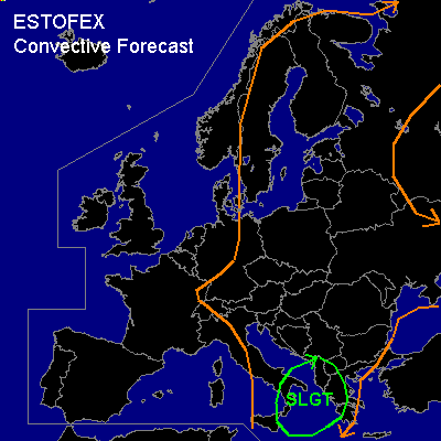
There is a slight risk of severe thunderstorms forecast across Central Mediterranean
General thunderstorms are forecast across Eastern and eatsern Central Europe, central Scandinavia
SYNOPSIS
Amplified ridge extends from Iberian Peninsula to Central Europe and further to northwestern Russia. To the east ... broad long-wave trough situated over eastern Europe and southern and central Mediterranean. Over the NE-Atlantic, intense trough will remain.
DISCUSSION
...Central and eastern Mediterranean...
Upper short-wave trough migrates along southern edge of mean eastern European trough. Associated vortmax is crossing southern Italy today and moves into southern central Mediterranean, where relatively moist boundary layer and steep lapse rates yield CAPE values in the order of 1000 J/kg. In the range of the trough ... thunderstorms have continued through the night over central Mediterranean and spread southeastward. Today ... thunderstorms should affect the central Mediterranean including Greece and southern Balkans. Strongest activity is forecast to the southeast of Italy... where CAPE should reach more than 1500 J/kg and low level wind shear southeast of the surface low should help for thunderstorm organization. A linear MCS should likely form and move ESE-ward reaching Greece late in the day. Severe wind gusts and large hail are forecast, as well as isolated tornados due to relatively moist boundary layer. To the NE ... scattered convection is forecast over the Balkans and Greece. Vertical wind shear should be quite low and single cells should be the main convective mode. However ... supercells are not ruled out due to orographically enhanced SRH and cell interaction.
...Eastern Europe and central Scandinavia...
East of European ridge ... moist and unstable airmass leads to daytime thunderstorms. Weak vertical wind shear and weak dynamic support will not lead to thunderstorm organization. Severe thunderstorms are not likely. Marginally severe hail and strong wind gusts should be the main threat. However ... outflow-inflow interaction could support some mesocyclones with the chance of severe hail.
#