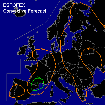

CONVECTIVE FORECAST
VALID 06Z THU 31/07 - 06Z FRI 01/08 2003
ISSUED: 30/07 18:51Z
FORECASTER: HUGO
General thunderstorms are forecast across SOUTHERN/CENTRAL, EASTERN & NORTHERN EUROPE INCLUDING SWEDEN & FINLAND
General thunderstorms are forecast across SOUTHERN SPAIN, CENTRAL & SOUTHERN PORTUGAL
SYNOPSIS
Large cyclonic feature South of Iceland will be dominating the Eastern Atlantic and more especially the British Isles throughout the forecast period with a ridge of the Azores high attempting to push into France to the South of this feature...Blocking mid and upper level anticyclonic feature will continue to dominate Northeastern regions of Europe as a slow retrogression process takes place in association with this feature...The rest of Europe will be associated by a slack pressure gradient with mesoscale features appearing in association with diurnal temperature changes and with a possible cyclonic heat-low development over parts of Southwestern Spain & Portugal.
DISCUSSION
...SOUTHERN/CENTRAL, EASTERN & NORTHERN EUROPE INCLUDING SWEDEN & FINLAND...
Airmass storms are expected to develop within the main GEN risk region as solar input increases during the morning and into the afternoon...Two quasi-stationary frontal features through Western regions of Scandinavia and into parts of Germany and Poland may act as focal points for convective development...Forecast soundings within the GEN risk region show forecast lowest 30hPa MLCAPE values in the range of 500j/kg to 1500j/kg with focal points into Poland and parts of Sweden & Finland during the latter stages of the afternoon...Deep layer shear throughout the forecast time period remains limited (0-6KM <20KT) and the only region of increase low level and deep layer shear will be on the Southern flank of the anticyclone over Northeastern Europe which will be effected by subsidence from the high pressure so no thunderstorm development is expected in association with this region...With favourable WBZ heights (7000-9000ft) over parts of Poland and into Sweden & Finland some reasonable sized hail (1-2")is possible along with some gusty surface winds (>35-40KT) but overall all convective parameters are expected to remain below severe limits...Convection will slowly decay after sunset...Convective activity over parts of Poland & into Sweden & Finland will be monitored during the course of the day for anything significant and a SLGT risk maybe issued if this is the case...
...SOUTHERN SPAIN, CENTRAL & SOUTHERN PORTUGAL...
Convection is expected to initiate during the course of the afternoon again in relation to diurnal heat processes and a possible heat-low mesoscale feature...Of significant importance is a major convergence zone within the GEN risk region which will also aid convective development and possible limited organisation into the afternoon...Forecast soundings during the afternoon and into the evening show lowest 30hPa MLCAPE values in excess of 1000j/kg over parts of Southern Portugal and with deep layer (0-6KM) possibly reaching 30-35KT coupled with some reasonable (0-3KM >100-150m2/s2) helicity values in association with a weak mid-level cyclonic feature and associated PVA region there is some scope for a more organised region of thunderstorm development over far Southwestern parts of Spain and more especially Southern Portugal...However of significant importance is that due to very high LCL and LFC bases forecast soundings show high levels of CIN (>-300j/kg)and with forecast CAP values in excess of 3C to 4C, as a result convection maybe be prohibited all together.
#