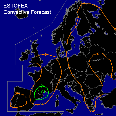

CONVECTIVE FORECAST
VALID 06Z WED 30/07 - 06Z THU 31/07 2003
ISSUED: 28/07 20:17Z
FORECASTER: HAVEN
There is a slight risk of severe thunderstorms forecast across SOUTH FRANCE, NORTHEAST SPAIN
General thunderstorms are forecast across SOUTHWESTERN AND NORTHEASTERN PART OF THE IBERIAN PENINSULA, FRANCE, EASTERN UK, BENELUX, WESTERN GERMANY, ZWITSERLAND, NORTHWEST ITALY
General thunderstorms are forecast across EASTERN SWEDEN, FINLAND, BALTIC STATES, NORTHWEST RUSSIA, POLAND, EAST CSECH REPUBLIC, SLOWAKIA, HUNGARY, PARTS OF UKRAINA, ROMANIA, YUGOSLAVIA, SZERBIA, BULGARIA, GREECE
SYNOPSIS
Upper low over southern British Isles is expected to move towards southeastern France during the period, while elongated upper trough from eastern germany to Szerbia remains almost stationary.
At lower levels... surface low over eastern England is filling. New shallow lows are forecast to develop over northeast France and Romania according to numerical model output. The main baroclinic zone from east-central Sweden over western Poland to the central Adriatic Sea remains stationary.
Numerous thunderstorms are expected to develop along and east of the mentioned frontal zone in an environment of moderate instability. Deep layer shear, however, will be too low to support organized severe storms.
DISCUSSION
...SOUTH FRANCE, NORTHEAST SPAIN...
In the vicinity of the upper low... cold air aloft and daytime heating will result into low to /at best/ moderate unstable thermodynamic profiles. A jet maximum /50+ kts at 500 hPa/ on the southwest side of the upper low will give enhanced upward vertical velocity in its left exit region, which is progged over southern France Wednesday evening. Deep layer shear will be more than sufficient for organized storms. Some of these may become supercellular, producing large hail, damaging winds and possibly a tornado.
#