CONVECTIVE FORECAST
VALID 06Z MON 28/07 - 06Z TUE 29/07 2003
ISSUED: 28/07 00:28Z
FORECASTER: VAN DER VELDE
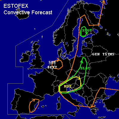
There is a moderate risk of severe thunderstorms forecast across Northern Italy, Hungary, Northern Yugoslavia.
There is a slight risk of severe thunderstorms forecast across SW Finland
General thunderstorms are forecast across Mostly eastern half of Europe
SYNOPSIS
Ridge of high pressure building over Western continental Europe is collocated with upper air trough with some instability. SFC low pressure areas are present over northern Sweden and over northern Italy, with a SFC trough along the weakening cold front stretching from Finland-Poland-Italy. Most unstable airmass is situated in the SFC trough just east of the somewhat weakening cold front. Low level pressure gradients are weak overall, except near Finland and over the southern slight risk region.
DISCUSSION
...Northern Italy, Hungary, Northern Yugoslavia...
Cold front associated with strong upward motions (in GFS model) should function as a vigorous trigger
of storms over the MDT risk region. Advected air already shows quite good lapse rates and moisture,
while current dewpoints range 16-22C. GFS 12Z shows CAPE climbing to 2000 J/kg 30hPa-MLCAPE,
so 1500 J/kg should be feasible at least. While 0-6 km shear will be around 25-35 kts, organized
clustered storms or perhaps a MCS (but low/mid level shear is modest) will be the likely convective mode.
These storms will be forming in dry midtroposheric environment with the risk of very strong
evaporatively driven downdrafts generating severe gusts (>50 kts) at the surface. These can be very
local microburst events or may be more widespread, contributing to forming a cold pool at low levels
which would enhance formation of a squall line/MCS. Widespread severe gusts and large hail
appear the main risk.
Unknown is the effect of the strong pressure gradients (MM5,GFS) just at the south side of the Alps
on the strength of the easterly winds. There seems to be a discrepancy between 10m winds and the pressure gradient
(GFS only has increased wind speeds around Tue 00Z).
Greater low level wind speeds from easterly directions may greatly enhance low level and deep layer shear here(!)
...SW-Finland...
CAPE should be enough for thundery activity, which in shear conditions forecast by GFS >25 kts 0-1 km / 25-40 kts 0-6 km / SRH >200 m2/s2, may
generate one or more mini supercell storms that produce large hail or perhaps an isolated tornado... but severe gusts at a
possible bow-echo configured MCS will be the main reason for this SLGT risk.
...The Netherlands, Nrn Germany...
Very weak shear and synoptic conditions, very moist lower levels and dry midlevels, and CAPE 100-300 J/kg seem very favorable for (water)spouts.
The main concern however is the extent of subsidence within the building high pressure ridge which could stabilize the air more than GFS 12Z likes.
#