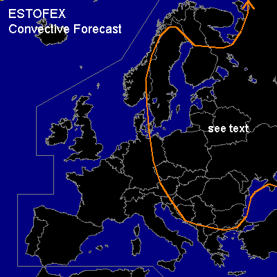

CONVECTIVE FORECAST
VALID 06Z FRI 25/07 - 06Z SAT 26/07 2003
ISSUED: 24/07 21:06Z
FORECASTER: GATZEN
General thunderstorms are forecast across Eastern and eastern Central Europe, northern and northeastern Europe
SYNOPSIS
Broad upper ridge remains over eastern Europe, and a relatively warm airmass dominates the region. Over western Europe ... intense qausistationary long-wave trough over the northeastern Atlantic yields a SWerly flow. At the surface ... frontal systems are crossing northwestern Europe, while occluded systems and convergence lines remains over eastern Central Europe.
DISCUSSION
...Eastern Europe...
Weak occlusions and surface convergences will affect the region from northwestern Russia to eastern Poland and further to the Balkans. Moisture pooling along those features and daytime insolation should lead to CAPE values in the order of 1500 J/kg. Tstms are expected during the day, initially along those features, spreading NE-ward. Vertical wind shear remains quite low ... and thunderstorm organization seems to be unlikely. However ... coverage of thunderstorms will be quite large, and outflow-inflow interaction could lead to enhanced SRH ... and short living mesocyclones are not ruled out with a chance of isolated large hail/ damaging wind gusts in the afternoon/ evening hours. Severe threat seems to be too limited to warrant a slight risk though.
...Eastern Central Europe, Scandinavia...
East of Atlantic trough ... moderate southwesterly to southerly flow with embedded short-wave troughs affects the warm airmass over eastern Central Europe and Scandinavia. Within the forecast periode ... one short wave will cross Scandinavia negatively tilted and synoptic scale uvm is expected. During the day ... CAPE values around 500 J/kg are forecast over Scandinavia and around 1000 J/kg over eastern Central Europe (GFS). Thunderstorms should form in the afternoon, initially along surface convergences and orographic features. Some stronger tstms are expected due to moderate vertical wind shear, and isolated large hail/ damaging wind gusts are not ruled out, exspecially in association with short living mesocyclones. Severe threat should be too limited to warrant a categorical risk.
#