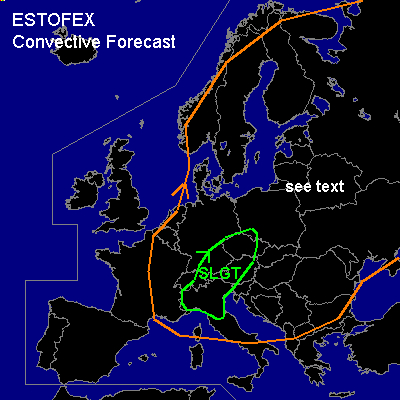

CONVECTIVE FORECAST - UPDATE
VALID 12Z THU 24/07 - 06Z FRI 25/07 2003
ISSUED: 24/07 10:51Z
FORECASTER: GATZEN
There is a slight risk of severe thunderstorms forecast across Southern Central Europe
SYNOPSIS
Over eastern Europe ... broad upper ridge is present ... while northwestern Europe is dominated by an upper level long wave trough and associated minor short wave troughs. One such feature is associated with a occlusion which will be moving into parts of France and the BENELUX during the forecast period.
DISCUSSION
...Southern Central Europe...
Intense short-wave trough is forecast to reach southern Central Europe within the forecast periode. Strong UVM should affect the Alpine region due to warm air advection and DCVA... At the surface ... observations show a well defined convergence line east of the occlusion over Bavaria, and some tstms have developed along this feature. Airmass east of the convergence line is characterized by a relative moist boundary layer. Steep lapse rates are present from 900 to 800 hPa, yielding CAPE values of some 100's J/kg. However ... daytime insolation is rather weak as cirrus- shield of Italian MCS covers the region. During the next hours ... synoptic forcing should strengthen ... and tstms should propagate eastward merging into a linear MCS. A cold pool should form west of this line and LEWP/ bow echoes could be possible along the leading edge of the system. Strong to severe wind gusts up to 65 m/s and isolated large hail are forecast. There will be a slight chance for tornadoes as well, as boundary layer seems to be rather moist/ LCLs should be quite low/ and CAPE density within the lower troposphere could be large /steep lapse rates above the boundary layer). Within the evening/ night hours ... MCS should migrate over Austria/ Czech Rep. and southern Poland. Severe wind gusts, isolated large hail and heavy rain should be the main severe threat.
...other areas...
See yesterday's convective forecast.
#