CONVECTIVE FORECAST
VALID 06Z THU 24/07 - 06Z FRI 25/07 2003
ISSUED: 23/07 19:10Z
FORECASTER: HUGO
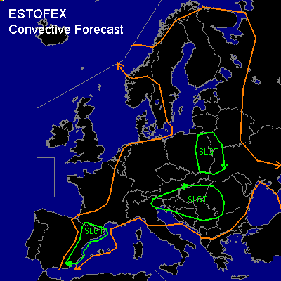
There is a slight risk of severe thunderstorms forecast across NORTHERN ITALY
General thunderstorms are forecast across CENTRAL-SOUTHERN, CENTRAL, EASTERN & NORTH-EASTERN EUROPE - EXPECT A SMALL REGION IN WESTERN RUSSIA
SYNOPSIS
Northwest Europe is dominated by an upper level long wave trough and associated minor short wave troughs...One such feature is associated with a surface occluded feature which will be moving into parts of France and the BENELUX during the course of the forecast period...The rest of Europe is situated underneath a slack upper level pressure pattern with only minor mesoscale features embedded within this flow developing in relation to diurnal heating and also minor anticyclonic development with a somewhat more substantial high pressure feature into parts of Western Russia, Belarus & the Ukraine towards the end of the forecast period.
DISCUSSION
...NORTH ITALY...
Northern parts of Italy during the course of the forecast period especially through daylight hours (Thursday) and in association with diurnal heating will be effected by a mesoscale surface low pressure feature which will place quite a rich region of upper forcing over the North Italy region aiding convective development...Convection is likely to initiate during the latter stages of the morning and into the first half of the afternoon as surface temperatures possibly exceed 30C...Forecast soundings within the SLGT risk region show a highly unstable atmosphere with lowest 30hPa MLCAPE values in excess of 1500j/kg and SBCAPE values possibly in excess of 2000j/kg with LI values -4 and -6C this leading to intense convective development by mid to late afternoon...1000mb forecast streamlines for the region show a major convergence zone within Northern Italy in association with Southern Apline wind's and also the sea breeze effect in conjunction with high inland temperatures, this will also aid a more organised risk of thunderstorm development over Northern Italy with the convergence zone also being associated with a high theta-w plume (18-20C) bringing heat and moisture to fuel convective activity...With deep layer shear (0-6KM) of between 30 and 40KT expected along with some reasonable helicity (0-3KM 100-120m2/s2) there is scope for multicell development and maybe the risk of supercell development in conjunction with above mentioned helicity values and deep layer shear especially over parts of Eastern Italy towards late Thursday, however with limited SCP value's the overall risk is expected to be low...With WBZ heights forecast to be in excess of 11000ft the risk of significant hail seems limited however with such intense CAPE values coupled with the deep layer shear there is likely to be some moderate sized hail especially in conjunction with any organised thunderstorm activity...There is expected to some strong wind gusts which may reach severe values (55-60KT)...Convection is likely to persist through a large part of the evening and first half of the night especially if any significant convective organisation has taken place before a gradual reduction in activity during the morning hours...
...WHOLE OF THE GEN RISK REGION (THE 'SEE TEXT' REGION)...
Diurnal convective activity is expected to initiate during the first half of the afternoon anywhere within the GEN risk region...Convective activity is expected to remain beneath severe limits however a region running down from Lithuania to Northern Romania in association with a frontal zone and also parts of Northern Germany could be at risk of seeing more intense convective activity in conjunction with higher CAPE values and generally a more convectively responsive atmosphere...However deep layer shear (0-6KM) is expected to be limited (<20KT) throughout the whole GEN risk region however parts of Northern Germany and Switzerland into the afternoon may reach values in excess of 25KT bringing the risk of something prolonged or slightly more organised in relation to convective activity...Otherwise any thunderstorm development will bring limited (small) sized hail and wind gusts will remain below severe limits...Parts of Germany & Switzerland as mentioned may experience something more organised and prolonged due to the deep layer shear helping to sustain any convective activity but again hail and wind gusts in association with the convective activity are likely to remain below severe limites...The regions mentioned above will be watched however for more significant organisation/activity during the course of the day and an upgrade to a SLGT risk maybe issued if needed...Any convective activity will slowly decay during the evening and into the first part of the night...
#