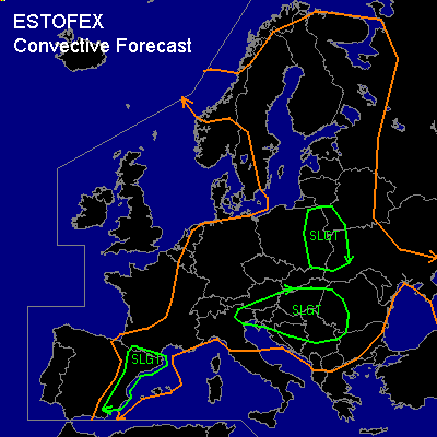
CONVECTIVE FORECAST
VALID 06Z WED 23/07 - 06Z THU 24/07 2003
ISSUED: 22/07 17:20Z
FORECASTER: HAVEN
There is a slight risk of severe thunderstorms forecast across EXTREME NE-ITALY INTO SRN-CARPATHIAN BASIN AND YUGOSLAVIA
There is a slight risk of severe thunderstorms forecast across E-POLAND AND W-UKRAINA
There is a slight risk of severe thunderstorms forecast across W-SPAIN
General thunderstorms are forecast across LARGE PARTS OF EASTERN, NORTHERN AND CENTRAL EUROPE
SYNOPSIS
Westerly upper flow pattern with several embedded shortwaves over Europe. Strong upper jet /80+ kts at 300 hPa/ from SW-Spain to NW-Italy will point its nose to Adriatic Sea and S-Balkan in the evening.
Main frontal zone, separating warm moist air to its east and cooler dryer air to its west, is situated from E-cntrl Sweden to cntrl-Poland to E-Austria to NW-Italy to S-Spain Wednesday at 06Z. This front moves slowly east over Scandinavia and eastern Europe, while almost stationary in Mediterranean areas.
Shortwave Wednesday at 06Z from cntrl NorthSea to French Alpes continues east and is expected from S-Sweden to Albania at 00Z. This feature will interact with the sfc front with numerous tstms expected in the afternoon and evening near frontal zone.
DISCUSSION
...EXTREME NE-ITALY INTO SRN-CARPATHIAN BASIN AND YUGOSLAVIA...
Wednesday at 06Z an MCS may be going over the S-Central Alps, this activity will spread E-SE and may re-develop in the course of the day.
Strongest UVM is expected in left-exit region of the forementioned jetstreak, ivof swrn edges of the Carpathian Basin, where also waa is occurring. As a result a sfc low will develop as calculated by several numerical models.
Moist air (dewpoints 18-20C) already in place, daytime heating and uvm will all contribute to increasing unstable profiles / CAPE 1000-2000 J/kg / in the late afternoon. Deep layer shear of 30-40 kts will result in multicell as the most likely convective mode, which could produce large hail and gusts near severe limits.
Further away, south from the front... 0-6 km shear of 40-45 kts will be sufficient for stormrotation. Near surface low over SW-Carpathian Basin
low level shear will be enhanced as H85 winds can be locally as high as 25-30 kts. Here, but also elsewhere terrain induced modifications of the low-level windfield could also enhance shear profiles with storms becoming mesocyclonic for a time. Any supercell that develops will be capable of producing large hail, damaging winds and perhaps a tornado.
...E-POLAND AND W-UKRAINA...
Quite unstable conditions (CAPE well above 1000 J/kg) are expected over this area, although AVN (2500 J/kg) is likely to exagerate. With sufficient forcing along the front and dynamic upward motions due to the approaching shortwave, thunderstorms will develop in the afternoon and evening. Though shear is weak, some storms may become briefly severe, producing strong to severe outflow winds since theta-e differences in the lowest 600 hPa will be on the order of 20-25K, thereby increasing evaporative cooling of downdrafts.
...W-SPAIN...
Shortwave at 06Z along the coast of Portugal continues slowly east and will reach W-Spain around midnight. The very humid airmass (dewpoints in excess of 20C) in the Spanish western coastal areas and daytime heating will make a 500-1000 J/kg of CAPE available.
In areas of enhanced sfc convergence the induced lift will likely be sufficient to break the capping inversion. 50+ kts deep layer shear will be sufficient for isolated supercells to form, producing large hail, damaging winds and possibly a tornado.
#