CONVECTIVE FORECAST
VALID 06Z MON 21/07 - 06Z TUE 22/07 2003
ISSUED: 21/07 01:22Z
FORECASTER: VAN DER VELDE
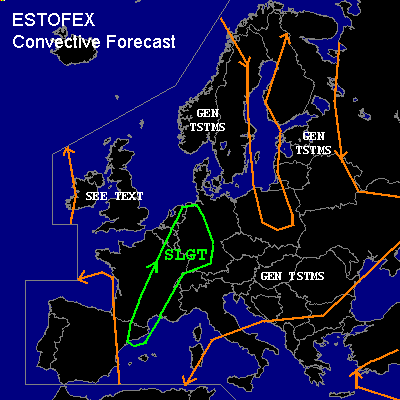
There is a slight risk of severe thunderstorms forecast across Central France, eastern Benelux, western Germany, northwestern Switzerland
General thunderstorms are forecast across Northeastern Spain, Southern France
General thunderstorms are forecast across The British Isles
General thunderstorms are forecast across much of Eastern Europe
SYNOPSIS
An upper/sfc level low is situated near Scotland and influences much of northwestern Europe.
Its cold front, almost parallel to the 500/700 hPa flow, stretches from eastern Spain through central France,
the Benelux and Denmark into Scandinavia. A wave in this CF will affect the Benelux area during the afternoon.
The air ahead of the CF allows for strong convection, with 30 hPa-mixed layer Theta-w of around 20 C.
The CF will have moved only a few hundred km eastwards (W/C Germany) by the end of the forecast period.
Quiter conditions reside in eastern Europe with a band of high Theta-w/unstable air from Finland down to Romania,
but with little forcing and shear, allowing for minor diurnal convective activity.
DISCUSSION
...Central France, eastern Benelux, western Germany, northwestern Switzerland...
Along and ahead of the cold front in a stationary position over the SLGT risk area, MLCAPE values are, like yesterday, expected to rise into 1500-2000 J/kg numbers. GFS with 2200 J/kg seems at the high end with also 2m dewpoints over 20 C. Current dewpoints (00Z) range between 16-19 C.
With deep-layer shear greater than 30 kts (0-6 km), BRN shear > 40m2s2, well-organized convective activity should develop with the potential of becoming MCS'ses,
given also the strong synoptic scale forcing. This seems most likely just northwest of the Alps (NE France, SW Germany) with slightly stronger shear up to 40 kts 0-6 km,
higher GFS convective precip indications.
Supercells should be marginally possible over the SLGT risk area given these shear conditions, where locally enhanced SREHs (synoptically already up to 150 m2/s2 in places) could be sufficient for generation of rotation in some cells.
Large hail and strong winds (Delta Theta-e > 20 K) should be the main threats, but tornadogenesis will be slightly enhanced as well due to low LCL/LFC heights along the CF, and most pronounced in western Germany according to GFS 12Z forecasts. However, deep- and shallow layer shear appear marginal at this time. 0-1 km shear for this matter appears best (> 15 kts) in southwestern Germany,
Switzerland and eastern France.
...Northeastern Spain, Southern France...
High-based storms appear possible which may become elevated supercells due to large deep-layer shear (40-60 kts) and SREH values (>100-200 m2/s2) and CAPE values over 1000 J/kg. GFS 12Z indicates significant synoptic scale upward motions that should trigger the storms. The storms will likely continue at night as increasing SREHs (GFS 12Z) indicate continued warm air advection.
Primary threats will be large hail and locally severe winds - potentially widespread if a MCS forms, the latter being most likely during the evening/night.
...The British Isles...
Convective activity (CAPE up to 500 J/kg) in weak shear, very low LCL/LFC and high vorticity environment
will likely produce quite a few funnel clouds and some water/landspouts.
#