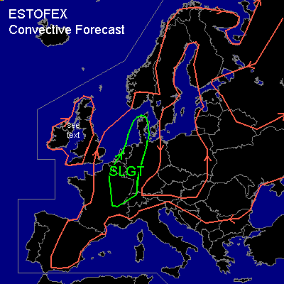

CONVECTIVE FORECAST - UPDATE
VALID 14Z SUN 20/07 - 06Z MON 21/07 2003
ISSUED: 20/07 14:39Z
FORECASTER: GROENEMEIJER
There is a slight risk of severe thunderstorms forecast across parts of Denmark, western Germany, the Benelux countries and northeastern France.
General thunderstorms are forecast across France, eastern Spain, the British Isles, The Benelux countries, Germany, Scandinavia, The Alps, the Balkans, the western Ukraine, Belarus the Baltic States and northern parts of western Russia.
SYNOPSIS
An upper low just northwest of Ireland will move slowly northeastward. Downstream... a large upper ridge with weak flow is present over much of Europe. At lower levels, warm and dry air is being advected northward over western Europe. Within a south southwesterly mid/upper flow over western Europe a vorticity maximum is located over northwestern France at 13 Z, moving north northeastward.
DISCUSSION
...Benelux, Northwestern Germany, Denmark...
A convergence line is located from the northern Netherlands to near Luxembourg at 13Z. Near and west of this line, SFC dew points have risen to 16 - 21 C. Another area of enhanced low-level moisture is located over southern denmark, where similar SFC dew points are measured. This moisture leads to higher than previously anticipated latent instability on the order of 1000 J/kg MLCAPE50 per Uccle (06447) /De Bilt (06260) /Emden (10200) and Schleswig (10035) soundings, which will likely increase somwhat further during the afternoon. On approach of the vort max, convection has initiated over north-central France. Additional convective development seems likely as the forcing for upward vertical motion will increase over the next few hours. The storms may well cluster into one or two MCSs moving north northeastward near the convergence line and also into Denmark.
It may be possible that some bowing structures develop, especially near the convergence line given rather favorable deep-layer shear on the order of 40 kts. Main threats of the convection will likely be damaging gusts, especially if bow-shaped elements manage to form. Also, some large hail is possible with the storms.
...eastern France, southwestern Germany...
Additional convective development is taking place further south over east central France and will likely increase as some slight DCVA is expected to overspread this area as well. Inverted-V type soundings in that area in combination with near 40 kts deep-layer shear implies that the storms will pose a threat of damaging gusts despite the low MLCAPE present in that area. Deep-layer shear will possibly allow some rotating updrafts /mesocyclones/ so that there will be an enhanced threat of large hail as well.
Expect the convection to gradually cluster into an MCS moving into southwestern Germany this evening. The MCS may be strongly backbuilding over the Rhone/Saone Valley as a southerly low-level jet forms in the valley.
...British Isles...
refer to latest convective forecast.
#