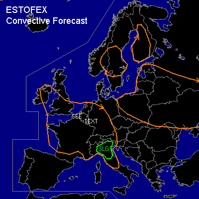

CONVECTIVE FORECAST
VALID 06Z WED 16/07 - 06Z THU 17/07 2003
ISSUED: 15/07 20:42Z
FORECASTER: HAVEN
There is a slight risk of severe thunderstorms forecast across NORTHERN ITALY
General thunderstorms are forecast across PARTS OF SOUTHERN AND CENTRAL BRITISH ISLES, FRANCE, BENELUX, WESTERN AND SOUTHERN GERMANY, WESTERN ALPINE AREAS
General thunderstorms are forecast across S-CENTRAL SCANDINAVIA, PARTS OF FINLAND, BALTIC STATES, POLAND, UKRAINA AND EXTREME WESTERN RUSSIA
SYNOPSIS
Upper ridge from Italy to west-Germany is slowly shifting east, whilst upper low over Biscay moves to northwest-France. Shortwave over southern-France rotates slowly around this low and will reach a line from northern-France to Switzerland to northern-Italy in the mid-evening.
Surface low just ahead of the upper low will move from Bretagne to southern-England. Axis of high theta-w in the low levels and associated trough/pre-frontal convergence line is situated from Bretagne to central-France Wednesday at the beginning of the forecast period and expected from east-Anglia to central-Benelux to southcentral-Germany Thursday at 00Z. The trough will be followed shortly by a coldfront.
DISCUSSION
...NORTHERN ITALY...
Moist boundary layer air, coupled with strong daytime heating and weak/moderate UVM due to the approaching shortwave will contribute to MLCAPES approaching 1000-1800 J/kg by late afternoon. A low level forcing mechanism seems hard to find over the area, although the southern fringe of the low-level-trough and orography or topography induced low-level-convergence could aid to sufficient lifting for thunderstorms to form.
Band of fairly strong w-sw winds at midlevels /deep layer shear of 40-50 kts/ should be supportive for the development of supercells, which could easily produce large hail and damaging winds. A 0-3km SRH of 150-200 m2s-2 will also be sufficient for tornadoes, although the calculated LCLs will limit tornado-threat a bit.
Also a theta-e difference of 20-25 K in the lowest 600 hPa of the atmosphere will be supportive of microbursts.
If the forementioned scenario works out
storms could be arranged into one or more large clusters in the evening hours with a continued threat of severe windgusts.
Due to the uncertainty about low-level triggering mechanisms, at the moment a slight risk seems the best choice. Upgrading to moderate could be necessary.
...S-ENGLAND, N- AND E-FRANCE, BENELUX, W- AND S-GERMANY...
Thunderstorm activity (possibly in the form of MCSs) present Wednesday at 06Z may weaken diurnally through the morning hours prior to intensifying by mid-afternoon over S-England, N- and E-France, where downstream airmass is expected to be destabilizing. Near axis of low-level high theta-w
area of moderate instability /MLCAPES of 1200-1800 J/kg / should develop by late afternoon.
Low level convergence along pre-frontal convergence line should allow thunderstorms to develop over S-England, N- and E-France, moving into Benelux and Germany in the late afternoon and evening hours.
With deep layer shear of 25-35 kts, most likely mode will be multicells, possibly arranged into a linear MCS as time progresses. Modification of the low level windfield by local topography may enhance shear-profiles, which could lead to brief rotating storms with large hail, damaging winds and possibly a tornado. The main mode however will be multicell and though a few borderline wind or hail events are possible with these storms, all over threat seems too low for a slight risk.
Pocket of relatively high SRH exists north of the mentioned convergence line, but the dry atmosphere and lack of forcing will make the development of storms not likely in this particular area.
#