CONVECTIVE FORECAST - UPDATE
VALID 15Z TUE 15/07 - 06Z WED 16/07 2003
ISSUED: 15/07 16:01Z
FORECASTER: GROENEMEIJER
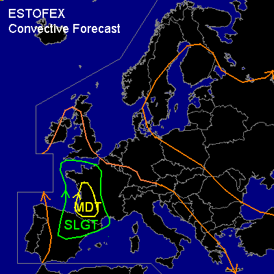
There is a moderate risk of severe thunderstorms forecast across southwestern France
There is a slight risk of severe thunderstorms forecast across an area surrounding the slight risk area including much of western and southern france and northern spain.
General thunderstorms are forecast across
SYNOPSIS
As a jet streak is moving northward over central Spain, upward vertical motion over in its left exit region is located over north-central Spain. The jet streak will propagate northeastward into France. For further details, refer to latest convective forecast.
DISCUSSION
...France...
A moist air-mass is present in the Loire and Garonne Valleys, where dew point temperatures are around 20 C. Surface temperatures have risen to around 32 C in this area, which upon modifying the 12Z soundings of Bordeaux (LFBD) and Brest (LFRB) implies about 2000 - 3000 J/kg SBCAPE and little CINH is present in the area.
Some storms are currently forming currently (15Z) over Normandy. This convection will be capabale of producing localised severe gusts and large hail, but the overall threat will be limited given that wind shear is quite low in that area. This activity is expected to move over the Channel region during this evening and possibly affect extreme southern England later tonight.
Main activity will arise on approach of the left exit region of the jetstreak currently (15Z) present over Spain, forcing for upward vertical motion will spread over southwestern France. Rapid development of convection is forecast over southwestern France in the next few hours. Deep-layer shear will increase to 40 - 55 knots over the area, which will be more than adequate for the development of supercells. Given the amount of instability and deep-layer shear, very large hail (>5 cm) will be possible, as well as severe gusts. Uncertain exists with respect to the amount of storm-relative helicity that will be present. Current thinking is that a developing low in the lee of the Pyrenees will enhance low-level helicity on its northern and eastern flanks, which is supported by the GFS and MM5 models. Therefore, a few tornadoes seem to be possible in the moderate risk area, especially in the upper Garonne valley region.
Later in the evening and overnight, the activity will likely cluster into a MCS that will move north to northnorthwestward over western France, reaching the Channel region at the end of the period. Though environmental deep-layer shear will gradually decrease near the MCS, the increasing organisation of the system as it keep being sustained by synoptic dynamics and the ingestion of unstable air will help severe threat to persist overnight. Main threats will then be large hail and severe gusts.
...northern Spain...
Some storms have developed over parts of north-central Spain along a cold front is analysed from near San Sebastian to near Murcia at 15 Z. Strong convergence of surface winds is evident over the upper Ebro valley, where moister air is advected westward through the valle. Ne storms appear to be forming in this area per satellite imagery. The 12Z Zaragoza sounding has about 1200 J/kg MLCAPE50 and shows a quite deep and dry boundary layer, implying storms will have a tendency to produce strong downdrafts. Expect the storm coverage to increase during the remainder of the afternoon and during the evening. Given ample deep-layer shear, some storms will likely become supercells. The main threats of these storms will be strong to severe gusts. Some large hail is also likely to occur in a few places. The storms may possibly cluster into a linear MCS, but this is a bit uncertain at the moment as the strongest forcing seems to be moving into France later this evening. The storms are expected to move eastward over northern Spain, only gradually deminishing in strength until early morning.
#