CONVECTIVE FORECAST - UPDATE
VALID 13Z SUN 13/07 - 06Z MON 14/07 2003
ISSUED: 13/07 13:03Z
FORECASTER: VAN DER VELDE
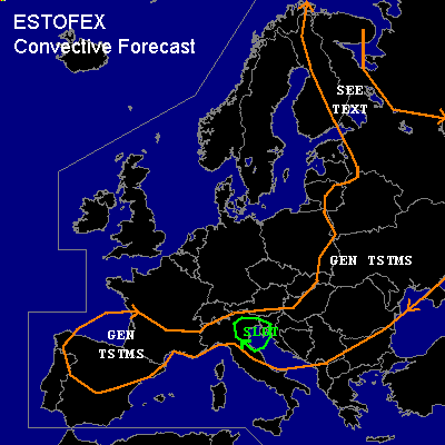
There is a slight risk of severe thunderstorms forecast across NE Italy
General thunderstorms are forecast across southern and eastern Europe
General thunderstorms are forecast across Finland and northern Russia
SYNOPSIS
High pressure area dominates northern and western Europe with stable conditions. At its eastern side, a shallow low sfc pressure zone with low 500 hPa temperatures/heights and high BL theta-w providing opportunities for widespread convection. Most upward motions are associated with the vorticity advection/cold front near the upper low over Eastern Europe, slowly progressing eastward to the Black Sea area by the end of the forecast period.
A weak cold front is approaching from the Atlantic and reaches Portugal near the end of the period. The thermal low pressure region over Iberia and SW France will deepen ahead of this system and will bring back the Spanish Plume causing thunderstorms over Western Europe later this week.
DISCUSSION
...NE Italy...
GFS 00Z indicating up to 2000 J/kg CAPE (30 hPa ML). 1500 J/kg should be possible given the 00Z and 06Z Cuneo-Levaldigi and Milano soundings with additional heating. Sea breeze provides the focus of convective initiation. Severe storms with a primary chance of large hail and locally severe outflow should be possible, given the >30 kts 0-6km shear in the eastern part of the area and even better BRN shear, while slightly enhanced and increasing helicities over 100 m2/s2 may also help sustaining updrafts. Low level shear is not significant and LCLs too high for any significant tornadoes.
...Finland, northern Russia...
Very moist profiles, very low LCL/LFCs, >1000 J/kg MLCAPE per GFS and ULWW Vologda sounding, and locally moderate deep layer shear up to 20 kts should cause widespread clustered convection with a chance of landspouts. The weak pressure gradients can lead to slow-moving storms that produce locally high amounts of precip and possibly flash-flooding.
#