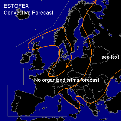
CONVECTIVE FORECAST
VALID 06Z FRI 11/07 - 06Z SAT 12/07 2003
ISSUED: 10/07 19:06Z
FORECASTER: GATZEN
General thunderstorms are forecast across western Russia
General thunderstorms are forecast across central Mediterranean
General thunderstorms are forecast across parts of northwestern Central Europe
General thunderstorms are forecast across parts of south-eastern Europe
SYNOPSIS
Upper long-wave trough placed over central eastern Europe. To the north, warm airmass spreads westward over northern Europe, where blocking ridge pattern dominates. To the southwest, north-westerly flow regime affects most of western and Central Europe and the Mediterranean. Relatively cold airmass spreads from north-western Europe into Central Europe, and reaches the Mediterranean after passing the Alps. At the surface ... cold front is forecast to reach Central Europe during the day.
DISCUSSION
...Western Russia...
North of upper long-wave trough over eastern Europe, warm and relatively moist airmass affects western Russia. Rawinsonde data do not show any well-mixed layers above the boundary, and low CIN/ relatively low CAPE is expected tomorrow over this region. Within this airmass ... thunderstorms should likely develop due to daytime heating, initially along outflow boundaries of thursday's storms. Weak easterly surface and mid/ upper tropospheric wind regime should not support storm organization, and single cells are forecast. However ... in the afternoon, widespread convection is expected ... and outflow boundaries could create locally enhanced SRH. Short-living mesocyclones are not ruled out with a chance of large hail, damaging wind gusts and probably a brief tornado due to low LCLs. Severe threat seems to be too low to warrant a categorical risk though.
...Central Mediterranean...
Above relatively moist boundary layer ... steep lapse rates are present over central and western Mediterranean, yielding to CAPE values in the order of 1000 J/kg in the afternoon, as GFS output suggests. Soundings indicate large CIN over most of the affected region. Thunderstorms will most likely develop in the afternnon over Italy due to daytime heating and sea breeze convergences. Organized convection is not expected as vertical wind shear remains low. However ... dry mid tropospheric layers suggest that strong wind gusts will be possible though.
#