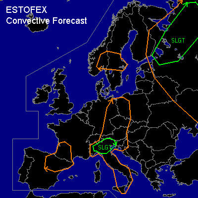

CONVECTIVE FORECAST
VALID 06Z THU 10/07 - 06Z FRI 11/07 2003
ISSUED: 09/07 18:03Z
FORECASTER: HUGO
General thunderstorms are forecast across SOME CENTRAL & EASTERN REGIONS OF EUROPE - *EXCEPT* - parts of BELARUS, LITHUANIA, LATIVA, ESTONIA, GREECE & TURKEY
SYNOPSIS
A large part of Central & Western Europe will be dominated by high pressure in association with a slack upper level anticyclonic pattern with a ridge of high pressure across these areas extending into parts of Scandinavia...A shortwave trough will be approaching the British Isles in association with a surface low pressure situated to the South of Iceland...A weak and often sometimes closed upper level low will be effecting parts of Eastern Europe throughout the forecast period in association with a weak area of surface low pressure (1000-1005mb) within these areas...
DISCUSSION
...GEN TSTSM RISK ZONE...
All the regions within the GEN TSTSM area are at risk of thunderstorm development in association with diurnal solar heating, some dynamical thunderstorm activity is possible in association with weak occluded fronts tied in with the slack region of low pressure over parts of Western Russia...Convection will initiate during late morning and into the early part of the afternoon, however convection and thunderstorm activity maybe present during the morning in association with the slack area of surface low pressure over parts of Eastern Europe that is mentioned within the synopsis discussion...Forecast MLCAPE values throughout the region are generally between 700 and 1500j/kg with main regions of relatively high (>1000j/kg) CAPE values over parts of Northern Italy and over Eastern regions of Europe in association with the slack region of surface low pressure...With limited deep layer shear (0-6KM <20KT) and no significant helicity (0-3KM <50m2/s2) the risk of organised thunderstorm activity is small or nil, however there is scope for some limited organisation to any thunderstorm activity over parts of Northeastern Europe as deep layer shear (0-6KM) values may reach 30KT and low level shear (0-1KM) values reach at least 15KT but even here nothing significant is expected...1000hPa streamlines over parts of Northern Italy show a high risk of a convergence zone from seabreezes within the region during tomorrow afternoon and evening and this could well aid some temporary organisation of thunderstorm activity before land temperatures reduce later in the day...Over parts of Northern Italy forecast soundings for tomorrow do show favourable WBZ heights (6500ft - 7500ft) and with CAPE in excess of >1200j/kg there is scope for some medium sized hail especially in this region...The whole GEN risk region could well see some moderate wind gusts and small to medium sized hailstone from single celled thunderstorm development...Any convective activity will slowly decay during the evening and overnight as solar input reduces...
#