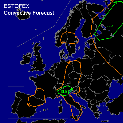

CONVECTIVE FORECAST
VALID 06Z WED 09/07 - 06Z THU 10/07 2003
ISSUED: 08/07 19:51Z
FORECASTER: HAVEN
There is a slight risk of severe thunderstorms forecast across SOUTH-KARELIJA AND PARTS OF NORTHWEST-RUSSIA
There is a slight risk of severe thunderstorms forecast across NORTH-ITALY
General thunderstorms are forecast across PARTS OF EAST-FINLAND, KARELIJA, NORTHWEST-RUSSIA, SOUTHERN-SCANDINAVIA, CENTRAL EUROPE, ITALY, SOUTH-FRANCE AND NORTH-SPAIN
SYNOPSIS
Rather weak NW-ly upper flow pattern over the area, with a shortwave crossing central Europe.
At lower levels... (modified) polar airmass over much of continental Europe with dewpoints of 10-15C, will contribute to low kinematic profiles. Area of most interest is further northeast, over northwestern Russia, where an almost stationary surface low is situated.
DISCUSSION
...SOUTH-KARELIJA AND NORTHWEST-RUSSIA...
A warmfront over SE-Finland and S-Karelija moves slowly north, with quite strong warm-advection causing decent vertical motion. South of this front the airmass is rather moist with dewpoints between 15 and 20C. The warmfront is followed by a coldfront, which will become stationary later on Wednesday. From the occlusion-point over extreme SE-Finland, a nearly stationary bentback-occlusion is aligned north-south towards eastern Ukraina.
Night-time thunderstorms might still be going in the morning hours. As surface temperatures rise, air will become increasingly unstable over the area with CAPE between 800 and 1500 J/kg. Although strongest vertical motions will occur in warm-advection regime /where at best some elevated CAPE is available/ frontal forcing is expected to be sufficient for thunderstorm development.
Deep layer shear on the order of 30 kts will make the most likely convective mode multicells. Some of these may produce marginal large hail and, given theta-e differences near 20K in the lowest 600 hPa, a few microbursts. Therefore this area is placed under a slight risk. Thunderstorms might very well be clustered into one or two MCSs with large rainfall amounts in the evening hours.
Generally the vertical windshear seems too low to support rotating updrafts. However... if, north of the warmfront over Karelija, elevated storms can be rooted in the boundary-layer... strong veering profiles will make supercells possible. At the moment this seems unlikely.
Also... outflow boundaries from developing or yesterdays convection could locally favourably modify the low level windshear, thereby increasing the chances for severe storms.
...CENTRAL EUROPE AND ITALY...
Scattered thunderstorms will be possible as shortwave crosses Central-Europe in the late afternoon and evening. Organized severe storms are not expected since both instability and vertical shear will be low.
Over N-Italy severe threat will be somewhat higher due to higher CAPE in the order of 1200-1700 J/kg. A few strong multicells might develop with large hail the main threat.
#