
CONVECTIVE FORECAST
VALID 06Z SUN 06/07 - 06Z MON 07/07 2003
ISSUED: 06/07 00:31Z
FORECASTER: VAN DER VELDE
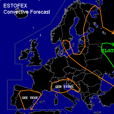
There is a slight risk of severe thunderstorms forecast across SW Russia and E Ukraine
General thunderstorms are forecast across E/NE Europe, S Sweden
General thunderstorms are forecast across N Italy, Kroatia
General thunderstorms are forecast across NE Spain
SYNOPSIS
Ridge of high pressure slowly builds eastward over Western Europe. Eastern Europe is affected by a large stationary low pressure area with weak gradients and unstable stratification.
DISCUSSION
...Southwestern Russia and Eastern Ukraine...
CAPEs forecast by GFS 12Z rise to 2000 J/kg number in the slight risk area. This is supported by yesterdays 12Z sounding of URRR near the Black Sea with >2700 J/kg MLCAPE. Weak to moderate deep layer shear of 20 kts 0-6 km and no significant helicities will not be sufficient for updraft rotation, but multicell storms with a threat of large hail and severe gusts appear likely if a cap can be sustained for long enough to maintain these CAPE numbers. This is more likely southward in the risk area.
Weak shear profiles and weak capping near the core of the low seem favorable for some funnel clouds which occasionally may reach the ground.
...NE Spain...
12Z yesterday Zaragosa sounding shows elevated instability while surrounded by generally dry profiles. The 1000 J/kg CAPE suggested by GFS should be sufficient for thunderstorms (some elevated) to develop along with the convergence over land due to diurnal heating. Deep layer/ BRN shear >40 m2s2 appears strong enough to support updraft rotation in some cells, but given the high LFCs, only a few isolated storms with some threat of large hail and strong gusts appears likely.
...mostly E/NE Europe and S Sweden...
Current instability in cooperation with weak shear, surface convergence and moist profiles are usually favorable for some funnel clouds which occasionally may reach the ground.
#