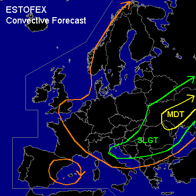

CONVECTIVE FORECAST
VALID 06Z FRI 04/07 - 06Z SAT 05/07 2003
ISSUED: 03/07 21:14Z
FORECASTER: GATZEN
There is a moderate risk of severe thunderstorms forecast across central Ukraina
There is a slight risk of severe thunderstorms forecast across eastern and southeastern Europe
General thunderstorms are forecast across northen and Central Europe, western Mediterranean
SYNOPSIS
Central European trough slowly progressing eastward. In the range of this trough ... maritime airmass spreads over west and Central Europe. Over southeastern Europe ... warm continental airmass that originates from northern Africa is present.
DISCUSSION
...Southeastern and Eastern Europe...
Cold front enters the region ... as upper level trough moves to the Balkans. Strong jet streak will move from central Italy to Bulgaria. Affected warm airmass is relatively dry and CAPE in the order of 1000 J/kg is suggested. Within the day ... thunderstorms should develop along the cold front and within the warm airmass. The formation of a convergence line due to DCVA ahead of approaching trough seems likely. Thunderstorms will possibly become severe/ supercellular as strong deep layer shear and moderate low level shear is present in the Balkans region. Strong wind gusts and large hail are expected. A tornado or two is not ruled out due to locally low LCL highs. Further to the east ... vertical wind shear will be somewhat lower. Warm air advection ahead of approaching trough is forecast north of the Black Sea, and warm front is expected over northern Ukraina. Within the night ... thunderstorms should go on and organize NW of the Black Sea. On Friday ... stratiform clouds could inhibit insolation somewhat. However ... thunderstorms should form within the warm air advection regime in the day. High CAPE values are expected due to adequate boundary moisture and surface winds should likely shift to the east in the range of the warm front, giving evidence of widespread enhanced SRH. If thunderstorms may root into the boundary layer north of the warm front ... supercells should develop ... with the chance of very large hail and damaging wind gusts. Along the warm front ... tornados should be possible due to low LCL highs.
#