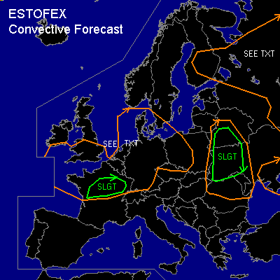

CONVECTIVE FORECAST
VALID 06Z WED 02/07 - 06Z THU 03/07 2003
ISSUED: 01/07 19:48Z
FORECASTER: HAVEN
There is a slight risk of severe thunderstorms forecast across UKRAIN
There is a slight risk of severe thunderstorms forecast across NORTH CENTRAL FRANCE
General thunderstorms are forecast across PARTS OF NORTHWEST RUSSIA AND FINLAND
General thunderstorms are forecast across PARTS OF WESTERN AND CENTRAL EUROPE
SYNOPSIS
South of a slow east-moving upper low over the North Sea, a w-sw flow is established over central and southern Europe. A negatively tilted upper trough at 06Z from W-Poland to Hungary continues northeast towards the Baltic States and Ukrain.
At the surface... Low over eastern-Poland will deepen significantly, move northeast and is expected over the Baltic States Thursday 00Z. Coldfront from surface low to Hungary will arrive at the Black Sea at 00Z.
DISCUSSION
...UKRAIN...
Moist warmsector air (Td around 18C), together with surface heating will contribute to an unstable atmosphere with MLCAPE between 500 and 1000 J/kg. Moderate dynamical UVM and lift by coldfront will initiate thunderstorms, since only a weak inhibition seems present. With 0-6km shear of around 40 kts, organized storms are expected. Strong multicells are the most likely mode, with marginal large hail and gusts near severe limits possible.
Expected deep layer shear and SRH-values between 100 and 200 m2s-2 indicates a supercell cannot be ruled out. Large hail, damaging winds and perhaps a tornado are all possible with any rotating storm that forms.
...NORTHWEST RUSSIA...
Moderate unstable conditions (MLCAPE around 1500 J/kg) are expected over parts of nw-Russia. Together with 15-20 kts of 0-1 km shear, storms that form may become organized. However... models shows sufficient forcing cannot be detected over the area. So initiation of storms, must be done by daytime-heating. A few severe events may be possible, but at the moment, the expected low coverage of the storms puts all-over severe threat below a slight risk.
...NORTH-CENTRAL FRANCE...
In the polar airmass over western Europe, scattered thunderstorms are expected. A few hundred J/kg of CAPE will be available for these storms, mainly in the afternoon and early evening, when instability is at its peak and a trough moves from the British Isles towards nw-France.
Since deep-layer shear is rather weak, severe threat is low. However... over N-Central France (around 48N), 0-1 km shear of 20-25 kts may be sufficient for good organization of storms, probably into lines or small bows. Storms could locally be severe with marginal large hail and windgusts of around 50 kts. A tornado cannot be ruled out, especially where local topography modifies the low-level wind environment.
...SOUTHERN NORTH SEA/GERMAN BIGHT AND SURROUNDING COASTAL AREAS...
In the lowest layers of the atmosphere, some instability, low vertical shear, sufficient moisture and cyclonical curved isobars, will make atmospheric conditions rather favourable for a few waterspouts. Especially over estuaries, where watertemperatures are nearly 20C. In the afternoon a spout will also be possible over land.
#