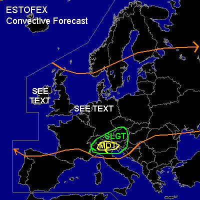

CONVECTIVE FORECAST
VALID 06Z TUE 01/07 - 06Z WED 02/07 2003
ISSUED: 30/06 21:22Z
FORECASTER: GATZEN
There is a moderate risk of severe thunderstorms forecast across southern Alpine region
There is a slight risk of severe thunderstorms forecast across northern Alpine region
General thunderstorms are forecast across northwestern Europe
General thunderstorms are forecast across eastern Europe
SYNOPSIS
Intense upper trough west of Europe will move to southern North Sea within the forecast periode. At it's southern and western edge, several vort-maxima will affect Central Europe. Over eastern Europe ... weakening upper trough will be dominant. Over southern Mediterranean... upper ridge will remain.
DISCUSSION
...Northwestern Europe...
The southern and western parts of western European trough are characterized by convectively mixed maritime airmass. Deep moisture and nearly no convective inhibition will likely allow for thunderstorms. Daytime heating could lead to low layer CAPE of several hundreds J/kg. Moderate to strong deep layer (speed) shear will be in place underneath the edge of the trough over Ireland and from the Biscayan gulf to southern Baltic Sea and will allow for thunderstorm organization. Foci of convective activity are expected underneath the right exit regions of vort-maxima rotating round the main trough, i.e. over Ireland, and over northwestern Central Europe. Over Ireland, relatively dry boundary layer should reduce severe potential significantly. Over Benelux, northwestern Central Europe and southern Scandinavia, very moist airmass and strong deep layer shear is present. Organized convection should form ahead of the vort-max and cross Benelux during the morning, and spread northeastward into northern Germany in the day. Bow echos could possibly form producing severe wind gusts up to 60 kts. Small hail is also expected. Due to orographically enhanced low level SRH, there may be a slight chance for brief tornados as well, especially in regions with very low LCLs.
...Northern Alpine region...
Very difficult weather situation is expected over the Alpine region. Strong upper jetstreak is expected over northern Italy in the evening, and strong DCVA is forecast over most of the Alpine region. Underneath this jet streak, a frontal wave is expected to form along the cold front over the Alps. This cold front is forecast to cross Germany till Wednesday morning. However ... there is a great uncertainty if the cold front will be able to cross Bavaria as well, because Foehn effects could cause a significant delay of the cold front propagation. Latest model output suggests that deep layer cold air advection and increasing surface pressure over southern Germany will destroy the Foehn, and the cold front should reach the Alps till the morning hours. If this scenario comes true, stratiform clouds are expected north of the Alps, and warm air advection ahead of intense vort-max should cause stratiform rain. Severe convection will be unlikely. However ... there is a great uncertainty about the Foehn development. If it will not be destroyed, cold airmass north of the Alps should be shallow, and insolation could allow for CAPE. Alpine Pumping due to orographic induced thermal circulation should result in northerly surface winds, and ahead of the strong upper SW-erly jetstreak strong low layer shear could form. However ... it seems that there exists a slight chance for severe convection north of the Alps at this time, and supercells may form if SRH will be in place. Thunderstorms should move eastward and affect Austria in the evening. Large hail, damaging wind gusts and probably a tornado or two are not ruled out. Later observations have to be awaited to estimate severe potential.
...Southern Alpine region, northern Italy...
Latest models suggest that cold front will enter the region from the SW. Moist boundary layer is present east of this cold front. Ahead of approaching jet streak, cyclogenesis is forecast over NW-ern Italy, and warm air advection will be in place over SE-ern Italy, where low level winds are forecast to back to SSE. If daytime heating will lead to CAPE, severe convection should likely form in the evening due to strong low layer and deep layer shear and strong synoptic scale upward vertical motion. Supercells are expected over NE-ern Italy moving eastward into N-ern Balkans. Large hail and high winds are forecast. There is also a significant potential for tornados if orographically enhanced SRH and low LCLs will be in place. Best chances should be present over the Po-Valley. Convection should merge into a MCS later in the evening with high winds and flash flooding the main severe threat.
#