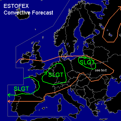

CONVECTIVE FORECAST - UPDATE
VALID 10Z MON 30/06 - 06Z TUE 01/07 2003
ISSUED: 30/06 10:09Z
FORECASTER: GROENEMEIJER
There is a slight risk of severe thunderstorms forecast across northern and northeastern France, western and southern Germany, northwestern Switzerland and southeastern and central parts of the Benelux countries
There is a slight risk of severe thunderstorms forecast across northern and northeastern poland, western Belarus and the extreme northwestern Ukraine.
There is a slight risk of severe thunderstorms forecast across northwestern Spain and parts of western France.
General thunderstorms are forecast across much of west-central and central Europe, the northern Balkans, a part of Belarus and a part of the Ukraine and a part of northwestern Russia.
SYNOPSIS
West of a ridge located from the British Isles to northern Italy at the beginning of the forecast period, a strong (120 kt @ 300 hPa) southwesterly mid/upper jet will move eastward into western europe. Downstream...over northern Poland, a vort. max. is moving eastsoutheastward into northern Belarus. A shortwave trough over northern Greece will move southward affecting the Aegean Sea area, reaching the eastern Mediterranean Sea near Cyprus at the end of the period.
DISCUSSION
...France, Benelux, Germany and Switzerland...
While warm air advection is sustaining elevated convective activity over the southern Benelux countries, clustered convective activity is forming over northwestern and north-central France near a poorly defined cold front as the exit region of the mid/upper jet gradually moves over the area. An area of low surface pressure (1002 hPa) to the SW of Luxembourg is expected to move gradually northward during the day and intensify.
Ahead of the area surface temperatures/dew points are forecast to be near 20/17 over northwestern France/Benelux and 25/17 to the east where low coverage of cloud is permitting strong insolation. MLCAPE30 should be able to rise to values on the order of 500 J/kg ahead of the system over much of north-central France and the Benelux while western Germany and eastern France may see somewhat higher values.
Potential for severe weather will increase as the mid/upper jet moves further eastward and low-level winds will increase over France, The Benelux, Switzerland and western Germany, locally to around 30 kts. Expect the coverage of storms over France to intensity while the chance of rotating updrafts rises while deep layer shear increases to around 70 knots.
Strong forcing and quite strong low-level shear suggests that most storms will organise into linear convective systems capable of producing strong wind gusts and posing a minor hail threat. Low LCL heights are expected over northern France, the southeastern Benelux countries, Rheinland and Nordrhein-Westfalen, ao that one or two weak tornadoes cannot be ruled out in those areas. Further south, LCLs will generally be higher, but since sfc winds are expected to remain southsoutheasterly in the upper Rhine Valley region and Baden-Wurttemberg, a quite helical inflow may be available to stroms forming in that region later today. Therefore, a small chance of tornadoes seems to be present there as well.
...northern and northeastern Poland, extreme western Belarus and the extreme northwestern Ukraine...
A small but vigorous vort. max. is analysed over northern Poland. Strong upward motions ahead of this system have been sustaining a cluster of thunderstorms over extreme northern Poland during the last night. Solar warming of a moderately moist boundary layer and cooling due to upward motions ahead op the system, will lead to destabilisation of the air-mass over the risk area. Expect stroms to develop over the area from the northwest during the afternoon. Deep-layer shear will be near 40 kts, and thereby strong enough for some rotating updrafts, so that there will be a threat of large hail despite the limited amount of CAPE. Also, some strong wind gusts are possible in the area. The activity will expand southeastward during the late afternoon and evening into the Ukraine. As shear is expected to slowly decrease and instability becomes lower, the severe threat seems to be lower in that area not warranting a slgt risk further to the southeast.
...northwestern Spain and parts of western France....
Clustered storms near a developing trough from Galicia northward to just southwestern of Bretagne will affect northern Spain this afternoon and western France overnight. As 850 hPa winds are expected to increase to around 40 knots on approach of this trough and low-level shear will be quite strong, there is a threat of severe wind gusts, especially on the passage of the trough. The strong low-level shear environment might also cause some rotating updrafts in places so that a short-lived tornado and some marginally severe hail cannot be ruled out.
#