CONVECTIVE FORECAST
VALID 06Z MON 30/06 - 06Z TUE 01/07 2003
ISSUED: 29/06 16:41Z
FORECASTER: GROENEMEIJER
+++ CORRECTED +++
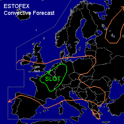
There is a slight risk of severe thunderstorms forecast across northern and northeastern France, the southeastern Benelux, parts of Germany and northwestern Switzerland
General thunderstorms are forecast across much of west-central and central Europe, parts of the Balkans and western Greece and a part of northwestern Russia
SYNOPSIS
West of a ridge located from the British Isles to northern Italy at the beginning of the forecast period, a strong (120 kt @ 300 hPa) southwesterly mid/upper jet will move eastward into western europe. Downstream...over northern Poland, a vort. max. is moving eastsoutheastward into northern Belarus. A shortwave trough over northern Greece will move southward affecting the Aegean Sea area, reaching the eastern Mediterranean Sea near Cyprus at the end of the period.
DISCUSSION
...SLGT RISK AREA...
Over northern France and Belgium, warm air advection should be able to initiate and sustain elevated convective activity in the early morning hours (ahead of the main forcing for upward vertical motion due to differential vorticity advection on approach of the mid/upper jet). This activity is expected to gradually move northeastward affecting The Benelux and parts of northwestern Germany. Potential for some severe weather will increase as the mid/upper jet moves into France and strong forcing will initiate more storms over northern, western and central parts of France in the afternoon hours while deep layer shear increases to around 70 knots. MLCAPE30 should be able to rise to values on the order of 500 J/kg ahead of the system over much of France, The Benelux and western germany and it may be somewhat higher over east-central France. Strong forcing and moderately strong (20 kt) low-level shear suggests that most storms will organise into linear convective systems producing strong wind gusts and posing a minor threat of large hail.
Given that low LCL heights are expected to be quite low over northern France, the southeastern Benelux countries,
Rheinland and Nordrhein-Westfalen, one or two weak tornadoes cannot be ruled out in those areas.
...British Isles...
In the early morning hours widespread moderate and heavy rain, locally accompanied by thunder, is expected to be affecting Wrn England and Srn Ireland. This activity is forecast to move slowly northward during the day. Later on, some scattered thunderstorms are expected to redevelop over southern parts of England.
#